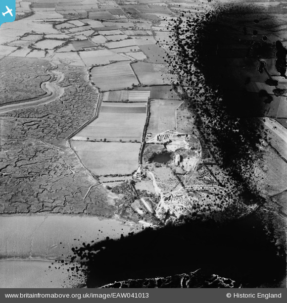
EAW041013 ENGLAND (1951). Freshwater Gravel Pit, Fingringhoe, 1951. This image has been produced from a damaged negative.
© Hawlfraint cyfranwyr OpenStreetMap a thrwyddedwyd gan yr OpenStreetMap Foundation. 2026. Trwyddedir y gartograffeg fel CC BY-SA.
Delweddau cyfagos (6)
Manylion
| Pennawd | [EAW041013] Freshwater Gravel Pit, Fingringhoe, 1951. This image has been produced from a damaged negative. |
| Cyfeirnod | EAW041013 |
| Dyddiad | 23-October-1951 |
| Dolen | |
| Enw lle | FINGRINGHOE |
| Plwyf | FINGRINGHOE |
| Ardal | |
| Gwlad | ENGLAND |
| Dwyreiniad / Gogleddiad | 604584, 219306 |
| Hydred / Lledred | 0.96973286976843, 51.834388392253 |
| Cyfeirnod Grid Cenedlaethol | TM046193 |


![[EAW041013] Freshwater Gravel Pit, Fingringhoe, 1951. This image has been produced from a damaged negative.](http://britainfromabove.org.uk/sites/all/libraries/aerofilms-images/public/100x100/EAW/041/EAW041013.jpg)
![[EAW041015] Freshwater Gravel Pit, Fingringhoe, 1951. This image has been produced from a print.](http://britainfromabove.org.uk/sites/all/libraries/aerofilms-images/public/100x100/EAW/041/EAW041015.jpg)
![[EAW041014] Freshwater Gravel Pit, Fingringhoe, 1951. This image has been produced from a damaged negative.](http://britainfromabove.org.uk/sites/all/libraries/aerofilms-images/public/100x100/EAW/041/EAW041014.jpg)
![[EAW041011] Freshwater Gravel Pit, Fingringhoe, 1951. This image has been produced from a damaged negative.](http://britainfromabove.org.uk/sites/all/libraries/aerofilms-images/public/100x100/EAW/041/EAW041011.jpg)
![[EAW041012] Freshwater Gravel Pit, Fingringhoe, 1951. This image has been produced from a damaged negative.](http://britainfromabove.org.uk/sites/all/libraries/aerofilms-images/public/100x100/EAW/041/EAW041012.jpg)
![[EAW041010] Freshwater Gravel Pit, Fingringhoe, 1951. This image has been produced from a damaged negative.](http://britainfromabove.org.uk/sites/all/libraries/aerofilms-images/public/100x100/EAW/041/EAW041010.jpg)


