
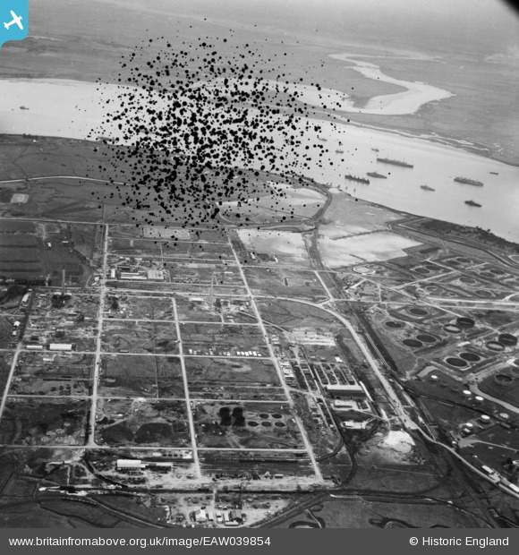
EAW039854 ENGLAND (1951). The Anglo-Iranian Oil Co oil refinery under construction, Isle of Grain, from the north-west, 1951. This image has been produced from a damaged negative.
© Hawlfraint cyfranwyr OpenStreetMap a thrwyddedwyd gan yr OpenStreetMap Foundation. 2026. Trwyddedir y gartograffeg fel CC BY-SA.
Delweddau cyfagos (11)
EAW039854

EAW034856

EAW048524

EAW034855

EAW048530

EAW045765

EAW045772

EAW045767

EAW045766

EAW045753

EAW045760

Manylion
| Pennawd | [EAW039854] The Anglo-Iranian Oil Co oil refinery under construction, Isle of Grain, from the north-west, 1951. This image has been produced from a damaged negative. |
| Cyfeirnod | EAW039854 |
| Dyddiad | 20-August-1951 |
| Dolen | |
| Enw lle | ISLE OF GRAIN |
| Plwyf | ISLE OF GRAIN |
| Ardal | |
| Gwlad | ENGLAND |
| Dwyreiniad / Gogleddiad | 586623, 175444 |
| Hydred / Lledred | 0.68594381465553, 51.446696979381 |
| Cyfeirnod Grid Cenedlaethol | TQ866754 |
Pinnau

redmist |
Wednesday 24th of June 2020 09:20:06 PM |