
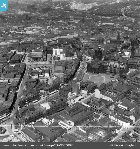
EAW037097 ENGLAND (1951). The Town Hall, City Hall and the city centre, Sheffield, 1951. This image has been produced from a print marked by Aerofilms Ltd for photo editing.
© Hawlfraint cyfranwyr OpenStreetMap a thrwyddedwyd gan yr OpenStreetMap Foundation. 2026. Trwyddedir y gartograffeg fel CC BY-SA.
Delweddau cyfagos (19)
EAW037097

EPW015462

EPW021135

EPW015460

EAW037094

EAW037095

EAW037096

EPW015596

EPW015459

EAW042501

EAW042500

EPW055237

EPW047988

EAW031288

EPW055242

EAW031289

EPW061497

EPW055233

EAW031290

Manylion
| Pennawd | [EAW037097] The Town Hall, City Hall and the city centre, Sheffield, 1951. This image has been produced from a print marked by Aerofilms Ltd for photo editing. |
| Cyfeirnod | EAW037097 |
| Dyddiad | 5-June-1951 |
| Dolen | |
| Enw lle | SHEFFIELD |
| Plwyf | |
| Ardal | |
| Gwlad | ENGLAND |
| Dwyreiniad / Gogleddiad | 435304, 387141 |
| Hydred / Lledred | -1.469220424972, 53.379675422749 |
| Cyfeirnod Grid Cenedlaethol | SK353871 |
Pinnau

Class31 |
Friday 13th of May 2016 10:43:13 PM | |

travellingpass |
Monday 5th of January 2015 04:13:54 PM |
