
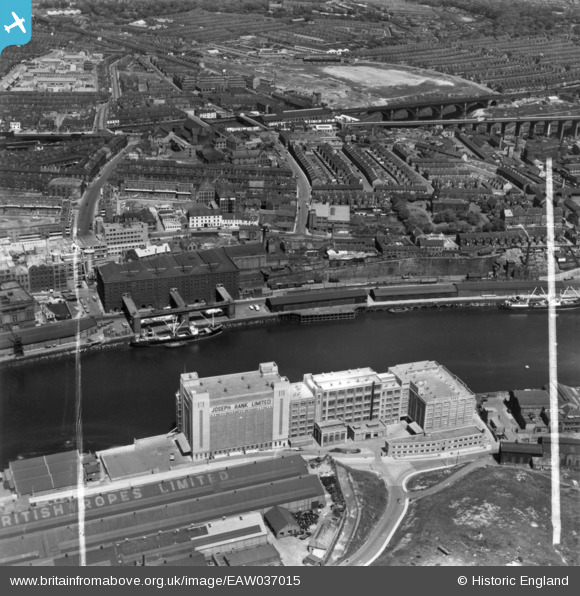
EAW037015 ENGLAND (1951). The Baltic Flour Mills, Quayside Goods Station and environs, Newcastle upon Tyne, 1951. This image has been produced from a print marked by Aerofilms Ltd for photo editing.
© Hawlfraint cyfranwyr OpenStreetMap a thrwyddedwyd gan yr OpenStreetMap Foundation. 2026. Trwyddedir y gartograffeg fel CC BY-SA.
Delweddau cyfagos (16)
EAW037015

EPW048818

EAW037014

EAW037016

EAW037011

EAW037009

EAW037010

EAW037013

EAW037018

EAW037017

EAW037008

EAW037012

EPW048233

EPW048232

EPW048819

EPW051085

Manylion
| Pennawd | [EAW037015] The Baltic Flour Mills, Quayside Goods Station and environs, Newcastle upon Tyne, 1951. This image has been produced from a print marked by Aerofilms Ltd for photo editing. |
| Cyfeirnod | EAW037015 |
| Dyddiad | 6-June-1951 |
| Dolen | |
| Enw lle | NEWCASTLE UPON TYNE |
| Plwyf | |
| Ardal | |
| Gwlad | ENGLAND |
| Dwyreiniad / Gogleddiad | 425921, 564145 |
| Hydred / Lledred | -1.5950350961631, 54.971172291493 |
| Cyfeirnod Grid Cenedlaethol | NZ259641 |
Pinnau

RupertHughes |
Friday 19th of March 2021 01:36:02 PM | |
|
RupertHughes |
Wednesday 24th of February 2021 02:13:56 PM | |
|
MB |
Sunday 4th of September 2016 10:12:58 AM |