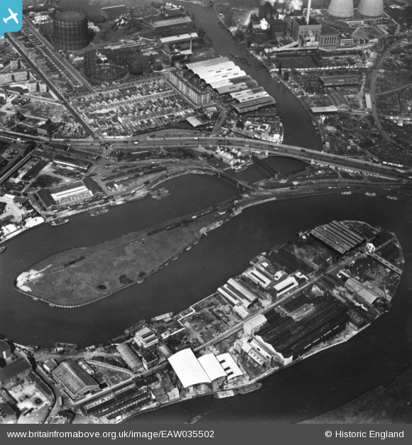
EAW035502 ENGLAND (1951). The Limmo Peninsula, Goodluck Hope/Leamouth Peninsula and environs, Canning Town, 1951. This image has been produced from a print.
© Hawlfraint cyfranwyr OpenStreetMap a thrwyddedwyd gan yr OpenStreetMap Foundation. 2026. Trwyddedir y gartograffeg fel CC BY-SA.
Delweddau cyfagos (19)
Manylion
| Pennawd | [EAW035502] The Limmo Peninsula, Goodluck Hope/Leamouth Peninsula and environs, Canning Town, 1951. This image has been produced from a print. |
| Cyfeirnod | EAW035502 |
| Dyddiad | 17-April-1951 |
| Dolen | |
| Enw lle | CANNING TOWN |
| Plwyf | |
| Ardal | |
| Gwlad | ENGLAND |
| Dwyreiniad / Gogleddiad | 539148, 181243 |
| Hydred / Lledred | 0.0054782294016086, 51.512472320334 |
| Cyfeirnod Grid Cenedlaethol | TQ391812 |
Pinnau

Class31 |
Saturday 28th of February 2015 08:10:58 AM |


![[EAW035502] The Limmo Peninsula, Goodluck Hope/Leamouth Peninsula and environs, Canning Town, 1951. This image has been produced from a print.](http://britainfromabove.org.uk/sites/all/libraries/aerofilms-images/public/100x100/EAW/035/EAW035502.jpg)
![[EAW035504] The Limmo Peninsula, Goodluck Hope/Leamouth Peninsula and environs, Canning Town, 1951. This image has been produced from a print.](http://britainfromabove.org.uk/sites/all/libraries/aerofilms-images/public/100x100/EAW/035/EAW035504.jpg)
![[EAW035503] The Limmo Peninsula, Goodluck Hope/Leamouth Peninsula and environs, Canning Town, 1951. This image has been produced from a print.](http://britainfromabove.org.uk/sites/all/libraries/aerofilms-images/public/100x100/EAW/035/EAW035503.jpg)
![[EAW035495] Jubilee Wharf on the Goodluck Hope/Leamouth Peninsula, Blackwall, 1951. This image has been produced from a print marked by Aerofilms Ltd for photo editing.](http://britainfromabove.org.uk/sites/all/libraries/aerofilms-images/public/100x100/EAW/035/EAW035495.jpg)
![[EAW035496] Jubilee Wharf on the Goodluck Hope/Leamouth Peninsula, Blackwall, 1951. This image has been produced from a print marked by Aerofilms Ltd for photo editing.](http://britainfromabove.org.uk/sites/all/libraries/aerofilms-images/public/100x100/EAW/035/EAW035496.jpg)
![[EAW035497] Jubilee Wharf on the Goodluck Hope/Leamouth Peninsula, Blackwall, 1951. This image has been produced from a print marked by Aerofilms Ltd for photo editing.](http://britainfromabove.org.uk/sites/all/libraries/aerofilms-images/public/100x100/EAW/035/EAW035497.jpg)
![[EAW035494] Jubilee Wharf on the Goodluck Hope/Leamouth Peninsula, Blackwall, 1951. This image has been produced from a print marked by Aerofilms Ltd for photo editing.](http://britainfromabove.org.uk/sites/all/libraries/aerofilms-images/public/100x100/EAW/035/EAW035494.jpg)
![[EAW035501] Jubilee Wharf on the Goodluck Hope/Leamouth Peninsula, Blackwall, 1951. This image has been produced from a print marked by Aerofilms Ltd for photo editing.](http://britainfromabove.org.uk/sites/all/libraries/aerofilms-images/public/100x100/EAW/035/EAW035501.jpg)
![[EAW035498] Jubilee Wharf on the Goodluck Hope/Leamouth Peninsula, Blackwall, 1951. This image has been produced from a print marked by Aerofilms Ltd for photo editing.](http://britainfromabove.org.uk/sites/all/libraries/aerofilms-images/public/100x100/EAW/035/EAW035498.jpg)
![[EAW035500] Jubilee Wharf on the Goodluck Hope/Leamouth Peninsula, Blackwall, 1951. This image has been produced from a print marked by Aerofilms Ltd for photo editing.](http://britainfromabove.org.uk/sites/all/libraries/aerofilms-images/public/100x100/EAW/035/EAW035500.jpg)
![[EAW035499] Jubilee Wharf on the Goodluck Hope/Leamouth Peninsula, Blackwall, 1951. This image has been produced from a print marked by Aerofilms Ltd for photo editing.](http://britainfromabove.org.uk/sites/all/libraries/aerofilms-images/public/100x100/EAW/035/EAW035499.jpg)
![[EAW035479] East India Dock Road and Commercial Wharf on the River Lea, South Bromley, 1951. This image has been produced from a print marked by Aerofilms Ltd for photo editing.](http://britainfromabove.org.uk/sites/all/libraries/aerofilms-images/public/100x100/EAW/035/EAW035479.jpg)
![[EAW037181] W.W. Howard Brothers and Co Ltd Timber Yard at Commercial Wharf, South Bromley, 1951. This image has been produced from a print marked by Aerofilms Ltd for photo editing.](http://britainfromabove.org.uk/sites/all/libraries/aerofilms-images/public/100x100/EAW/037/EAW037181.jpg)
![[EAW035481] East India Dock Road, Oban Street, Moness Street, Portree Street and Commercial Wharf on the River Lea, South Bromley, 1951. This image has been produced from a print marked by Aerofilms Ltd for photo editing.](http://britainfromabove.org.uk/sites/all/libraries/aerofilms-images/public/100x100/EAW/035/EAW035481.jpg)
![[EAW035482] East India Dock Road, Oban Street, Moness Street, Portree Street and Commercial Wharf on the River Lea, South Bromley, 1951. This image has been produced from a print marked by Aerofilms Ltd for photo editing.](http://britainfromabove.org.uk/sites/all/libraries/aerofilms-images/public/100x100/EAW/035/EAW035482.jpg)
![[EAW035484] East India Dock Road, Oban Street, Moness Street, Portree Street and Commercial Wharf on the River Lea, South Bromley, 1951. This image has been produced from a print marked by Aerofilms Ltd for photo editing.](http://britainfromabove.org.uk/sites/all/libraries/aerofilms-images/public/100x100/EAW/035/EAW035484.jpg)
![[EAW035477] Oban Street, Moness Street, Portree Street and Commercial Wharf on the River Lea, South Bromley, 1951. This image has been produced from a print marked by Aerofilms Ltd for photo editing.](http://britainfromabove.org.uk/sites/all/libraries/aerofilms-images/public/100x100/EAW/035/EAW035477.jpg)
![[EAW035483] Oban Street, Moness Street, Portree Street and Commercial Wharf on the River Lea, South Bromley, 1951. This image has been produced from a print marked by Aerofilms Ltd for photo editing.](http://britainfromabove.org.uk/sites/all/libraries/aerofilms-images/public/100x100/EAW/035/EAW035483.jpg)
![[EAW035480] Oban Street, Moness Street, Portree Street and Commercial Wharf on the River Lea, South Bromley, 1951. This image has been produced from a print marked by Aerofilms Ltd for photo editing.](http://britainfromabove.org.uk/sites/all/libraries/aerofilms-images/public/100x100/EAW/035/EAW035480.jpg)