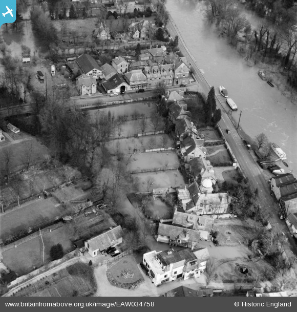
EAW034758 ENGLAND (1951). The gardens of Green Hedges to The Twelfth House on Ray Mead Road in flood, Maidenhead, 1951
    © Hawlfraint cyfranwyr OpenStreetMap a thrwyddedwyd gan yr OpenStreetMap Foundation. 2025. Trwyddedir y gartograffeg fel CC BY-SA.
  
Delweddau cyfagos (11)
Manylion
| Pennawd | [EAW034758] The gardens of Green Hedges to The Twelfth House on Ray Mead Road in flood, Maidenhead, 1951 | 
| Cyfeirnod | EAW034758 | 
| Dyddiad | 22-March-1951 | 
| Dolen | |
| Enw lle | MAIDENHEAD | 
| Plwyf | |
| Ardal | |
| Gwlad | ENGLAND | 
| Dwyreiniad / Gogleddiad | 490055, 181588 | 
| Hydred / Lledred | -0.70174052053051, 51.525535686889 | 
| Cyfeirnod Grid Cenedlaethol | SU901816 | 
Pinnau
Byddwch y cyntaf i ychwanegu sylw at y ddelwedd hon!
 
             
  ![[EAW034758] The gardens of Green Hedges to The Twelfth House on Ray Mead Road in flood, Maidenhead, 1951](http://britainfromabove.org.uk/sites/all/libraries/aerofilms-images/public/100x100/EAW/034/EAW034758.jpg) 
  
                                          ![[EAW034759] The gardens of Green Hedges to The Twelfth House on Ray Mead Road in flood, Maidenhead, 1951](http://britainfromabove.org.uk/sites/all/libraries/aerofilms-images/public/100x100/EAW/034/EAW034759.jpg) 
 ![[EPW022722] Bridge Eyot, Maidenhead, 1928](http://britainfromabove.org.uk/sites/all/libraries/aerofilms-images/public/100x100/EPW/022/EPW022722.jpg) 
 ![[EAW021596] Maidenhead Bridge and the surrounding area, Maidenhead, 1949. This image has been produced from a print.](http://britainfromabove.org.uk/sites/all/libraries/aerofilms-images/public/100x100/EAW/021/EAW021596.jpg) 
 ![[EAW021599] Maidenhead Bridge and the surrounding area, Maidenhead, 1949. This image has been produced from a print.](http://britainfromabove.org.uk/sites/all/libraries/aerofilms-images/public/100x100/EAW/021/EAW021599.jpg) 
 ![[EAW003664] Extensive flooding along the River Thames, Maidenhead, 1947](http://britainfromabove.org.uk/sites/all/libraries/aerofilms-images/public/100x100/EAW/003/EAW003664.jpg) 
 ![[EAW003665] Extensive flooding around Ray Park Avenue, Maidenhead, 1947](http://britainfromabove.org.uk/sites/all/libraries/aerofilms-images/public/100x100/EAW/003/EAW003665.jpg) 
 ![[EAW021597] Maidenhead Bridge and the surrounding area, Maidenhead, 1949. This image has been produced from a print.](http://britainfromabove.org.uk/sites/all/libraries/aerofilms-images/public/100x100/EAW/021/EAW021597.jpg) 
 ![[EAW013949] Maidenhead Bridge and the River Thames, Maidenhead, from the south, 1948. This image has been produced from a damaged negative.](http://britainfromabove.org.uk/sites/all/libraries/aerofilms-images/public/100x100/EAW/013/EAW013949.jpg) 
 ![[EAW029470] Maidenhead Bridge, the railway viaduct and River Thames, Taplow, 1950](http://britainfromabove.org.uk/sites/all/libraries/aerofilms-images/public/100x100/EAW/029/EAW029470.jpg) 
 ![[EAW003666] Flooding around Maidenhead Bridge and Bridge Road, Maidenhead, from the east, 1947](http://britainfromabove.org.uk/sites/all/libraries/aerofilms-images/public/100x100/EAW/003/EAW003666.jpg)