
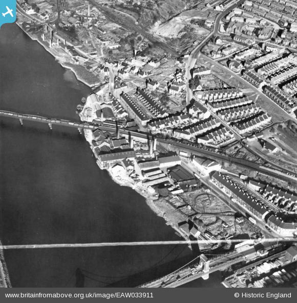
EAW033911 ENGLAND (1950). The Adamsez Ltd Sanitary Ware Works on Scotswood Road and environs, Scotswood, 1950. This image has been produced from a print marked by Aerofilms Ltd for photo editing.
© Hawlfraint cyfranwyr OpenStreetMap a thrwyddedwyd gan yr OpenStreetMap Foundation. 2026. Trwyddedir y gartograffeg fel CC BY-SA.
Delweddau cyfagos (10)
EAW033911

EAW033912
, Scotswood, 1950. This image has been produced from a damaged negative.")
EAW033914

EAW033913

EAW033915

EAW033910
, Scotswood, 1950. This image has been produced from a damaged negative.")
EAW033916

EAW033918

EAW033917

EAW033909
, Blaydon, 1950. This image has been produced from a damaged negative.")
Manylion
| Pennawd | [EAW033911] The Adamsez Ltd Sanitary Ware Works on Scotswood Road and environs, Scotswood, 1950. This image has been produced from a print marked by Aerofilms Ltd for photo editing. |
| Cyfeirnod | EAW033911 |
| Dyddiad | 19-October-1950 |
| Dolen | |
| Enw lle | SCOTSWOOD |
| Plwyf | |
| Ardal | |
| Gwlad | ENGLAND |
| Dwyreiniad / Gogleddiad | 419878, 563834 |
| Hydred / Lledred | -1.6894649299197, 54.968654983158 |
| Cyfeirnod Grid Cenedlaethol | NZ199638 |
Pinnau

AndyC |
Monday 6th of December 2021 02:44:42 PM |