
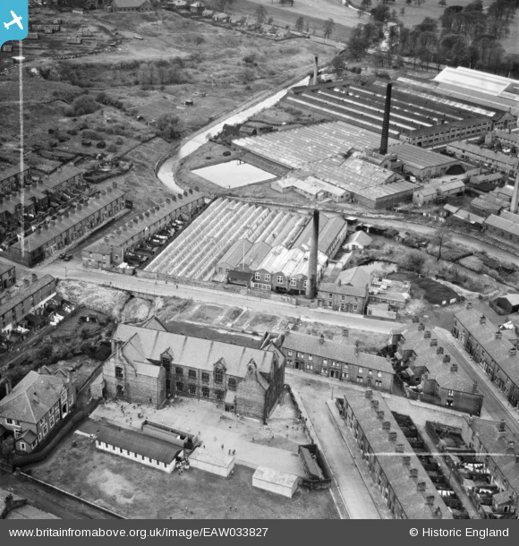
EAW033827 ENGLAND (1950). Primrose Mill and St Peter's R.C. Church and Primary School, Mill Hill, 1950. This image was marked by Aerofilms Ltd for photo editing.
© Hawlfraint cyfranwyr OpenStreetMap a thrwyddedwyd gan yr OpenStreetMap Foundation. 2026. Trwyddedir y gartograffeg fel CC BY-SA.
Delweddau cyfagos (6)
EAW033827

EAW033826

EAW033829

EAW033825

EAW033828

EAW033830

Manylion
| Pennawd | [EAW033827] Primrose Mill and St Peter's R.C. Church and Primary School, Mill Hill, 1950. This image was marked by Aerofilms Ltd for photo editing. |
| Cyfeirnod | EAW033827 |
| Dyddiad | 16-October-1950 |
| Dolen | |
| Enw lle | MILL HILL |
| Plwyf | |
| Ardal | |
| Gwlad | ENGLAND |
| Dwyreiniad / Gogleddiad | 366665, 426833 |
| Hydred / Lledred | -2.5054124561391, 53.736595814544 |
| Cyfeirnod Grid Cenedlaethol | SD667268 |
Pinnau

Matt Aldred edob.mattaldred.com |
Friday 8th of March 2024 06:28:04 PM | |

powerpop |
Wednesday 4th of March 2020 05:38:34 PM | |
|
powerpop |
Sunday 29th of January 2017 01:17:32 AM |