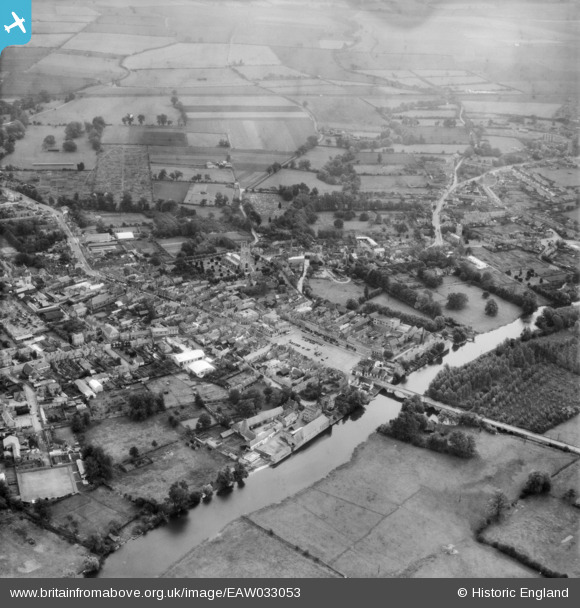
EAW033053 ENGLAND (1950). The town, St Neots, from the north-west, 1950
    © Hawlfraint cyfranwyr OpenStreetMap a thrwyddedwyd gan yr OpenStreetMap Foundation. 2025. Trwyddedir y gartograffeg fel CC BY-SA.
  
Delweddau cyfagos (7)
Manylion
| Pennawd | [EAW033053] The town, St Neots, from the north-west, 1950 | 
| Cyfeirnod | EAW033053 | 
| Dyddiad | 3-October-1950 | 
| Dolen | |
| Enw lle | ST NEOTS | 
| Plwyf | ST. NEOTS | 
| Ardal | |
| Gwlad | ENGLAND | 
| Dwyreiniad / Gogleddiad | 518156, 260320 | 
| Hydred / Lledred | -0.26984366161988, 52.227989526285 | 
| Cyfeirnod Grid Cenedlaethol | TL182603 | 
 
             
  ![[EAW033053] The town, St Neots, from the north-west, 1950](http://britainfromabove.org.uk/sites/all/libraries/aerofilms-images/public/100x100/EAW/033/EAW033053.jpg) 
  
                                          ![[EAW033047] The Market Square and town, St Neots, 1950](http://britainfromabove.org.uk/sites/all/libraries/aerofilms-images/public/100x100/EAW/033/EAW033047.jpg) 
 ![[EPW028952] The town centre, St Neots, 1929. This image has been produced from a copy-negative.](http://britainfromabove.org.uk/sites/all/libraries/aerofilms-images/public/100x100/EPW/028/EPW028952.jpg) 
 ![[EAW033050] The town, St Neots, 1950](http://britainfromabove.org.uk/sites/all/libraries/aerofilms-images/public/100x100/EAW/033/EAW033050.jpg) 
 ![[EAW033052] The town, St Neots, 1950](http://britainfromabove.org.uk/sites/all/libraries/aerofilms-images/public/100x100/EAW/033/EAW033052.jpg) 
 ![[EAW033051] The town, St Neots, 1950](http://britainfromabove.org.uk/sites/all/libraries/aerofilms-images/public/100x100/EAW/033/EAW033051.jpg) 
 ![[EAW033049] St Mary's Church, the High Street and town, St Neots, 1950](http://britainfromabove.org.uk/sites/all/libraries/aerofilms-images/public/100x100/EAW/033/EAW033049.jpg) 
  The Parish Church of St Mary The Virgin.
 The Parish Church of St Mary The Virgin.