
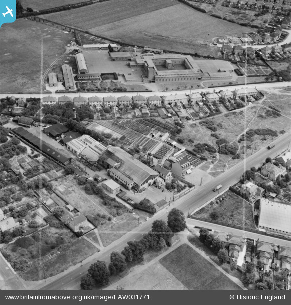
EAW031771 ENGLAND (1950). Knight's Boundary Nursery and Gardens and Mellow Lane Comprehensive School, Hillingdon Heath, 1950. This image was marked by Aerofilms Ltd for photo editing.
© Hawlfraint cyfranwyr OpenStreetMap a thrwyddedwyd gan yr OpenStreetMap Foundation. 2026. Trwyddedir y gartograffeg fel CC BY-SA.
Delweddau cyfagos (10)
EAW031771

EAW031770

EAW031769

EAW031774

EAW031773

EAW031766

EAW031767

EAW031768

EAW031772

EPW031276

Manylion
| Pennawd | [EAW031771] Knight's Boundary Nursery and Gardens and Mellow Lane Comprehensive School, Hillingdon Heath, 1950. This image was marked by Aerofilms Ltd for photo editing. |
| Cyfeirnod | EAW031771 |
| Dyddiad | 8-August-1950 |
| Dolen | |
| Enw lle | HILLINGDON HEATH |
| Plwyf | |
| Ardal | |
| Gwlad | ENGLAND |
| Dwyreiniad / Gogleddiad | 508221, 182194 |
| Hydred / Lledred | -0.43976357147743, 51.527793476054 |
| Cyfeirnod Grid Cenedlaethol | TQ082822 |
Pinnau

Matt Aldred edob.mattaldred.com |
Thursday 7th of March 2024 05:09:03 PM | |

CH |
Saturday 15th of November 2014 09:54:37 PM |