
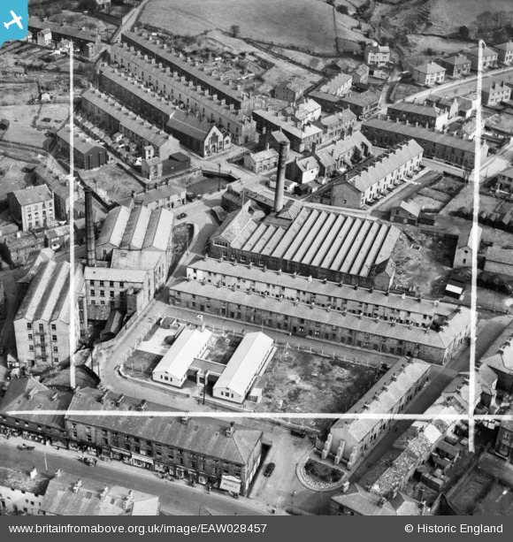
EAW028457 ENGLAND (1950). Higher Mill, Rawtenstall, 1950. This image was marked by Aerofilms Ltd for photo editing.
© Hawlfraint cyfranwyr OpenStreetMap a thrwyddedwyd gan yr OpenStreetMap Foundation. 2026. Trwyddedir y gartograffeg fel CC BY-SA.
Delweddau cyfagos (7)
EAW028457

 0°
0m
EAW028455
 63°
13m
EAW028456
 67°
20m
EAW028458
 75°
27m
EAW028452
 73°
30m
EAW028453
 93°
36m
EAW028454
 114°
58m
Manylion
| Pennawd | [EAW028457] Higher Mill, Rawtenstall, 1950. This image was marked by Aerofilms Ltd for photo editing. |
| Cyfeirnod | EAW028457 |
| Dyddiad | 25-March-1950 |
| Dolen | |
| Enw lle | RAWTENSTALL |
| Plwyf | |
| Ardal | |
| Gwlad | ENGLAND |
| Dwyreiniad / Gogleddiad | 381391, 423073 |
| Hydred / Lledred | -2.2819205365802, 53.70353064908 |
| Cyfeirnod Grid Cenedlaethol | SD814231 |
Pinnau
 Springside Methodist Church, Newchurch Road, Rawtenstall |

wadey |
Wednesday 28th of October 2026 05:21:54 PM |
| Newchurch Road |
wadey |
Wednesday 28th of October 2026 05:03:45 PM |
| Springside |
wadey |
Wednesday 28th of October 2026 05:02:49 PM |
| Mill Gate |
wadey |
Wednesday 28th of October 2026 05:01:56 PM |
| Daisy Hill |
wadey |
Wednesday 28th of October 2026 05:01:15 PM |
| Bank Street |
wadey |
Wednesday 28th of October 2026 05:00:06 PM |
| East Parade |
wadey |
Wednesday 28th of October 2026 04:58:44 PM |
| South Street |
wadey |
Wednesday 28th of October 2026 04:57:33 PM |