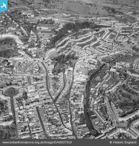
EAW027310 ENGLAND (1949). Lansdown Road, Hedgemead Park and the surrounding city, Bath, 1949
    © Hawlfraint cyfranwyr OpenStreetMap a thrwyddedwyd gan yr OpenStreetMap Foundation. 2025. Trwyddedir y gartograffeg fel CC BY-SA.
  
Manylion
| Pennawd | [EAW027310] Lansdown Road, Hedgemead Park and the surrounding city, Bath, 1949 | 
| Cyfeirnod | EAW027310 | 
| Dyddiad | 19-October-1949 | 
| Dolen | |
| Enw lle | BATH | 
| Plwyf | |
| Ardal | |
| Gwlad | ENGLAND | 
| Dwyreiniad / Gogleddiad | 375085, 165555 | 
| Hydred / Lledred | -2.358097753097, 51.387994092372 | 
| Cyfeirnod Grid Cenedlaethol | ST751656 | 
Pinnau
Byddwch y cyntaf i ychwanegu sylw at y ddelwedd hon!
 
             
  ![[EAW027310] Lansdown Road, Hedgemead Park and the surrounding city, Bath, 1949](http://britainfromabove.org.uk/sites/all/libraries/aerofilms-images/public/100x100/EAW/027/EAW027310.jpg) 
  
                                          ![[EPW053140] Roman Road, Cleveland Bridge and surroundings, Bath, 1937](http://britainfromabove.org.uk/sites/all/libraries/aerofilms-images/public/100x100/EPW/053/EPW053140.jpg) 
 ![[EPW048381] The city, Bath, from the north-east, 1935](http://britainfromabove.org.uk/sites/all/libraries/aerofilms-images/public/100x100/EPW/048/EPW048381.jpg) 
 ![[EPW033152] The city from Pulteney Bridge to Lansdown Crescent, Bath, 1930](http://britainfromabove.org.uk/sites/all/libraries/aerofilms-images/public/100x100/EPW/033/EPW033152.jpg)