
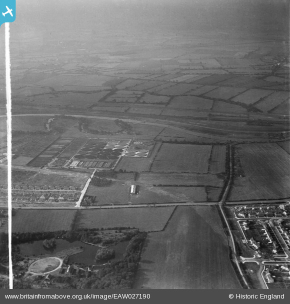
EAW027190 ENGLAND (1949). Sewage Works off Doncaster Road and the surrounding countryside, Doncaster, from the south-east, 1949. This image was marked by Aerofilms Ltd for photo editing.
© Hawlfraint cyfranwyr OpenStreetMap a thrwyddedwyd gan yr OpenStreetMap Foundation. 2026. Trwyddedir y gartograffeg fel CC BY-SA.
Delweddau cyfagos (5)
EAW027190

EPR000425

EAW027194

EAW027193

EAW027189

Manylion
| Pennawd | [EAW027190] Sewage Works off Doncaster Road and the surrounding countryside, Doncaster, from the south-east, 1949. This image was marked by Aerofilms Ltd for photo editing. |
| Cyfeirnod | EAW027190 |
| Dyddiad | 12-October-1949 |
| Dolen | |
| Enw lle | DONCASTER |
| Plwyf | |
| Ardal | |
| Gwlad | ENGLAND |
| Dwyreiniad / Gogleddiad | 460456, 406014 |
| Hydred / Lledred | -1.0874823189354, 53.547033285261 |
| Cyfeirnod Grid Cenedlaethol | SE605060 |
Pinnau
Byddwch y cyntaf i ychwanegu sylw at y ddelwedd hon!
Cyfraniadau Grŵp
From left to right. Center Ground: Wheatley Hills Allotments next to the old course of the River Don (tree lined oxbow lake). Sandall Sewage Works, Little Lane (road) Clay Lane (road) now Clay Lane West. Fore Ground: Truro Avenue (Wheatley Estate), Derby Road, Barnby Dun Road, Sandall Park, Clay Lane Estate. Cleared ground for Wheatley Hall Road or maybe sewers for new estate? Distance: Sheffield and South Yorkshire Navigation, River Don Flood Drain, Flood Banks, Arksey (village), Arksey Ings, Almholm (village), The Burgy Banks (Pilkintons Glass Works Tip). |

AndyLongSandall |
Friday 27th of June 2014 08:04:55 PM |