
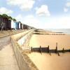
EAW025893 ENGLAND (1949). Walton Cliffs, Cliff Way, The Leas and environs, Frinton-On-Sea, from the south-east, 1949

© Hawlfraint cyfranwyr OpenStreetMap a thrwyddedwyd gan yr OpenStreetMap Foundation. 2026. Trwyddedir y gartograffeg fel CC BY-SA.
Delweddau cyfagos (2)
EAW025893

EAW025892

Manylion
| Pennawd | [EAW025893] Walton Cliffs, Cliff Way, The Leas and environs, Frinton-On-Sea, from the south-east, 1949 |
| Cyfeirnod | EAW025893 |
| Dyddiad | 10-August-1949 |
| Dolen | |
| Enw lle | FRINTON-ON-SEA |
| Plwyf | FRINTON AND WALTON |
| Ardal | |
| Gwlad | ENGLAND |
| Dwyreiniad / Gogleddiad | 624683, 220470 |
| Hydred / Lledred | 1.261757558941, 51.837116096561 |
| Cyfeirnod Grid Cenedlaethol | TM247205 |
Pinnau

redmist |
Sunday 18th of December 2022 07:13:29 PM | |
|
cptpies |
Friday 23rd of October 2015 12:20:41 PM | |
Onthecoast |
Monday 31st of March 2014 09:39:46 AM |
Cyfraniadau Grŵp

Type 22 pillbox, Frinton-on-Sea |
cptpies |
Friday 23rd of October 2015 12:22:39 PM |