
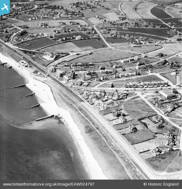
EAW024797 ENGLAND (1949). Marine Drive and environs, Saltdean, 1949
© Hawlfraint cyfranwyr OpenStreetMap a thrwyddedwyd gan yr OpenStreetMap Foundation. 2026. Trwyddedir y gartograffeg fel CC BY-SA.
Delweddau cyfagos (3)
EAW024797

 0°
0m
EAW024796
 52°
141m
EAW024798
 44°
200m
Manylion
| Pennawd | [EAW024797] Marine Drive and environs, Saltdean, 1949 |
| Cyfeirnod | EAW024797 |
| Dyddiad | 12-July-1949 |
| Dolen | |
| Enw lle | SALTDEAN |
| Plwyf | |
| Ardal | |
| Gwlad | ENGLAND |
| Dwyreiniad / Gogleddiad | 538339, 101934 |
| Hydred / Lledred | -0.036673016655575, 50.79986794211 |
| Cyfeirnod Grid Cenedlaethol | TQ383019 |
Pinnau
 Saltdean Drive |

Greens_Peace |
Sunday 15th of November 2026 04:24:54 PM |
| Is this a lake? |
printerspie |
Monday 2nd of August 2021 08:58:32 AM |
Sort of, according to the 1938 revision of the 25 inch Ordnance Survey map it is a boating lake. It had certainly gone by the late 1950's when I started visiting my Grandparents who lived in Saltdean Drive https://maps.nls.uk/view/103675081 |
Greens_Peace |
Sunday 15th of November 2026 04:23:56 PM |
| 'White Briar' Chorley Avenue |
moke72 |
Sunday 12th of January 2014 04:51:39 PM |
| Shops on Longridge Avenue |
moke72 |
Sunday 12th of January 2014 04:47:45 PM |

Alan McFaden |
Sunday 12th of January 2014 09:43:12 AM | |
|
Alan McFaden |
Sunday 12th of January 2014 09:40:18 AM | |
| Saltdean Lido |
Switches |
Saturday 21st of December 2013 04:27:35 PM |

