
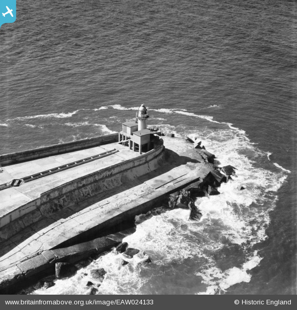
EAW024133 ENGLAND (1949). South Gare Lighthouse, Dormanstown, 1949
© Hawlfraint cyfranwyr OpenStreetMap a thrwyddedwyd gan yr OpenStreetMap Foundation. 2026. Trwyddedir y gartograffeg fel CC BY-SA.
Manylion
| Pennawd | [EAW024133] South Gare Lighthouse, Dormanstown, 1949 |
| Cyfeirnod | EAW024133 |
| Dyddiad | 22-June-1949 |
| Dolen | |
| Enw lle | DORMANSTOWN |
| Plwyf | |
| Ardal | |
| Gwlad | ENGLAND |
| Dwyreiniad / Gogleddiad | 455757, 528372 |
| Hydred / Lledred | -1.1358378995929, 54.647254244726 |
| Cyfeirnod Grid Cenedlaethol | NZ558284 |
Pinnau

Matt Aldred edob.mattaldred.com |
Tuesday 1st of December 2020 07:14:49 PM | |

Fantasma |
Friday 7th of March 2014 04:28:15 PM | |
|
Fantasma |
Friday 7th of March 2014 04:27:43 PM | |
Link to a photograph of the wind powered lighthouse railway in action: http://gizmodo.com/5823929/12-brilliant-examples-of-lighthouse-technology/ |
Lynda Tubbs |
Wednesday 6th of August 2014 02:03:34 PM |
|
Fantasma |
Friday 7th of March 2014 04:24:05 PM | |
|
cptpies |
Friday 10th of January 2014 09:51:05 AM |
Cyfraniadau Grŵp
I have spent many an hour here on watch at the coastguard lookout which was situated just out of the frame. I was a watchkeeper at the Teesmouth Marine Rescue Sub Centre which Co-Ordinated Marine Rescue along the coast from Filey Brigg to Sunderland. We monitored the marine emergency wavebands and could call in the necessary resources such as Search and Rescue helicopters and Royal National Lifeboat Institution lifeboats. I have seen seas breaking over the top of this lighthouse. Just a small point but we always called this area South Gare although I note that the Ordnance Survey call this the South Pier. |

Class31 |
Friday 7th of March 2014 09:07:39 AM |
I share Class 31's puzzlement at the name South Pier attributed to this image - for all of my life this area has been known as South Gare. Wikipedia defines South Gare as the reclaimed land and breakwater at this location on the south side of the mouth of the River Tees. Ordnance Survey maps available on the Vision of Britain website clearly refer to South Gare Breakwater. Similarly the lighthouse, although unnamed on any maps I have viewed, is also known as South Gare Lighthouse - see Wikipedia - and I have never, until now, known it to have any other name. Being privately owned (currently by PD Ports), this lighthouse is missing from many lists of UK lighthouses which seem to concentrate on those owned by Trinity House. |
Fantasma |
Friday 7th of March 2014 09:07:39 AM |

WWII Coast Artillery Searchlight Emplacements. |
cptpies |
Friday 10th of January 2014 09:51:39 AM |