
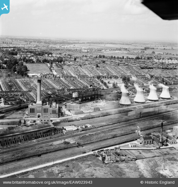
EAW023943 ENGLAND (1949). Spa Road Power Station, Lincoln, from the south, 1949
© Hawlfraint cyfranwyr OpenStreetMap a thrwyddedwyd gan yr OpenStreetMap Foundation. 2026. Trwyddedir y gartograffeg fel CC BY-SA.
Delweddau cyfagos (11)
EAW023943

EAW023940

EAW023944

EAW023941

EAW023942

EAW023946

EAW023938

EAW023939

EAW023945

EAW023947

EAW015721

Manylion
| Pennawd | [EAW023943] Spa Road Power Station, Lincoln, from the south, 1949 |
| Cyfeirnod | EAW023943 |
| Dyddiad | 20-June-1949 |
| Dolen | |
| Enw lle | LINCOLN |
| Plwyf | |
| Ardal | |
| Gwlad | ENGLAND |
| Dwyreiniad / Gogleddiad | 498678, 370944 |
| Hydred / Lledred | -0.52169485266068, 53.226080574852 |
| Cyfeirnod Grid Cenedlaethol | SK987709 |
Pinnau

Ian |
Sunday 28th of November 2021 08:24:53 PM | |
|
Ian |
Sunday 28th of November 2021 08:24:12 PM | |
|
Ian |
Sunday 28th of November 2021 08:22:30 PM | |
|
Ian |
Sunday 28th of November 2021 08:20:37 PM | |
|
Ian |
Sunday 28th of November 2021 08:10:56 PM |