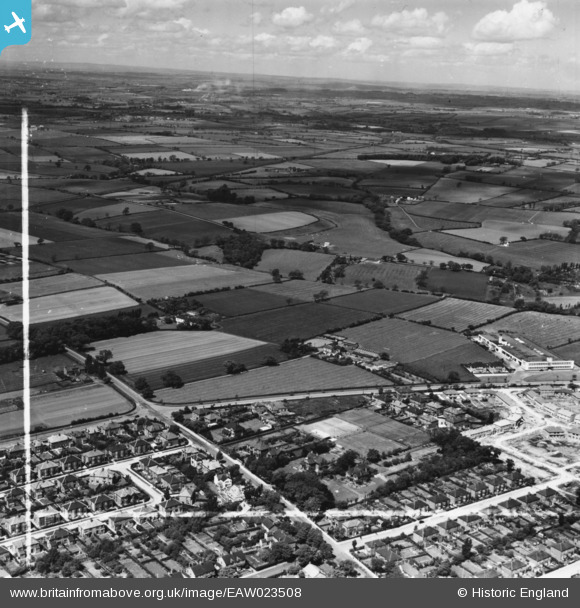
EAW023508 ENGLAND (1949). Bishopton Road, White House Farm and the Daylight Bakery off Bishopton Avenue, Stockton-on-Tees, from the south-east, 1949. This image has been produced from a print marked by Aerofilms Ltd for photo editing.
© Hawlfraint cyfranwyr OpenStreetMap a thrwyddedwyd gan yr OpenStreetMap Foundation. 2026. Trwyddedir y gartograffeg fel CC BY-SA.
Delweddau cyfagos (20)
Manylion
| Pennawd | [EAW023508] Bishopton Road, White House Farm and the Daylight Bakery off Bishopton Avenue, Stockton-on-Tees, from the south-east, 1949. This image has been produced from a print marked by Aerofilms Ltd for photo editing. |
| Cyfeirnod | EAW023508 |
| Dyddiad | 28-May-1949 |
| Dolen | |
| Enw lle | STOCKTON-ON-TEES |
| Plwyf | |
| Ardal | |
| Gwlad | ENGLAND |
| Dwyreiniad / Gogleddiad | 442954, 519893 |
| Hydred / Lledred | -1.3354934122795, 54.572304834209 |
| Cyfeirnod Grid Cenedlaethol | NZ430199 |
Pinnau

prgreen |
Monday 23rd of November 2020 09:06:21 PM | |

prgreen |
Monday 23rd of November 2020 09:05:31 PM |


![[EAW023508] Bishopton Road, White House Farm and the Daylight Bakery off Bishopton Avenue, Stockton-on-Tees, from the south-east, 1949. This image has been produced from a print marked by Aerofilms Ltd for photo editing.](http://britainfromabove.org.uk/sites/all/libraries/aerofilms-images/public/100x100/EAW/023/EAW023508.jpg)
![[EAW020572] White House Farm, Stockton-on-Tees, from the east, 1948](http://britainfromabove.org.uk/sites/all/libraries/aerofilms-images/public/100x100/EAW/020/EAW020572.jpg)
![[EAW020577] Ralph Spark & Sons Ltd Daylight Bakery on Bishopton Avenue, construction of housing around Glaisdale Avenue and surrounding countryside, Stockton-on-Tees, from the south-east, 1948](http://britainfromabove.org.uk/sites/all/libraries/aerofilms-images/public/100x100/EAW/020/EAW020577.jpg)
![[EAW023507] Bishopton Road, the Newham Grange Estate and Daylight Bakery off Bishopton Avenue, Stockton-on-Tees, from the south-east, 1949. This image has been produced from a print marked by Aerofilms Ltd for photo editing.](http://britainfromabove.org.uk/sites/all/libraries/aerofilms-images/public/100x100/EAW/023/EAW023507.jpg)
![[EAW023513] Bishopton Avenue and White House Farm, Stockton-on-Tees, from the south-east, 1949. This image was marked by Aerofilms Ltd for photo editing.](http://britainfromabove.org.uk/sites/all/libraries/aerofilms-images/public/100x100/EAW/023/EAW023513.jpg)
![[EAW023505] The Daylight Bakery off Bishopton Avenue, Stockton-on-Tees, from the south-east, 1949. This image has been produced from a print marked by Aerofilms Ltd for photo editing.](http://britainfromabove.org.uk/sites/all/libraries/aerofilms-images/public/100x100/EAW/023/EAW023505.jpg)
![[EAW016860] Ralph Spark & Sons Ltd Daylight Bakery on Bishopton Avenue and construction of housing around Farndale Green, Stockton-on-Tees, 1948. This image was marked by Aerofilms Ltd for photo editing.](http://britainfromabove.org.uk/sites/all/libraries/aerofilms-images/public/100x100/EAW/016/EAW016860.jpg)
![[EAW020578] Ralph Spark & Sons Ltd Daylight Bakery on Bishopton Avenue and surrounding countryside, Stockton-on-Tees, from the south-east, 1948. This image was marked by Aerofilms Ltd for photo editing.](http://britainfromabove.org.uk/sites/all/libraries/aerofilms-images/public/100x100/EAW/020/EAW020578.jpg)
![[EAW023506] The Daylight Bakery off Bishopton Avenue, Stockton-on-Tees, from the south-east, 1949. This image has been produced from a print marked by Aerofilms Ltd for photo editing.](http://britainfromabove.org.uk/sites/all/libraries/aerofilms-images/public/100x100/EAW/023/EAW023506.jpg)
![[EAW020583] Ralph Spark & Sons Ltd Daylight Bakery on Bishopton Avenue, construction of housing around Glaisdale Avenue and surrounding countryside, Stockton-on-Tees, from the east, 1948](http://britainfromabove.org.uk/sites/all/libraries/aerofilms-images/public/100x100/EAW/020/EAW020583.jpg)
![[EAW020571] Ralph Spark & Sons Ltd Daylight Bakery on Bishopton Avenue, Stockton-on-Tees, from the south-east, 1948. This image was marked by Aerofilms Ltd for photo editing.](http://britainfromabove.org.uk/sites/all/libraries/aerofilms-images/public/100x100/EAW/020/EAW020571.jpg)
![[EAW016858] Ralph Spark & Sons Ltd Daylight Bakery on Bishopton Avenue, Stockton-on-Tees, from the south, 1948. This image has been produced from a damaged negative.](http://britainfromabove.org.uk/sites/all/libraries/aerofilms-images/public/100x100/EAW/016/EAW016858.jpg)
![[EAW023510] The Daylight Bakery, Stockton-on-Tees, 1949. This image was marked by Aerofilms Ltd for photo editing.](http://britainfromabove.org.uk/sites/all/libraries/aerofilms-images/public/100x100/EAW/023/EAW023510.jpg)
![[EAW016856] Ralph Spark & Sons Ltd Daylight Bakery on Bishopton Avenue, Stockton-on-Tees, from the east, 1948. This image was marked by Aerofilms Ltd for photo editing.](http://britainfromabove.org.uk/sites/all/libraries/aerofilms-images/public/100x100/EAW/016/EAW016856.jpg)
![[EAW016859] Ralph Spark & Sons Ltd Daylight Bakery on Bishopton Avenue, Stockton-on-Tees, from the east, 1948. This image was marked by Aerofilms Ltd for photo editing.](http://britainfromabove.org.uk/sites/all/libraries/aerofilms-images/public/100x100/EAW/016/EAW016859.jpg)
![[EAW016861] Ralph Spark & Sons Ltd Daylight Bakery on Bishopton Avenue and construction of housing around Farndale Green, Stockton-on-Tees, 1948](http://britainfromabove.org.uk/sites/all/libraries/aerofilms-images/public/100x100/EAW/016/EAW016861.jpg)
![[EAW023509] The Daylight Bakery and houses at Newham Grange under construction, Stockton-on-Tees, from the east, 1949. This image was marked by Aerofilms Ltd for photo editing.](http://britainfromabove.org.uk/sites/all/libraries/aerofilms-images/public/100x100/EAW/023/EAW023509.jpg)
![[EAW020574] White House Farm, Stockton-on-Tees, 1948. This image was marked by Aerofilms Ltd for photo editing.](http://britainfromabove.org.uk/sites/all/libraries/aerofilms-images/public/100x100/EAW/020/EAW020574.jpg)
![[EAW023515] Stockton Grange looking towards the Daylight Bakery, Stockton-on-Tees, from the south, 1949. This image was marked by Aerofilms Ltd for photo editing.](http://britainfromabove.org.uk/sites/all/libraries/aerofilms-images/public/100x100/EAW/023/EAW023515.jpg)
![[EAW020579] Ralph Spark & Sons Ltd Daylight Bakery on Bishopton Avenue and surrounding countryside, Stockton-on-Tees, from the east, 1948. This image was marked by Aerofilms Ltd for photo editing.](http://britainfromabove.org.uk/sites/all/libraries/aerofilms-images/public/100x100/EAW/020/EAW020579.jpg)