
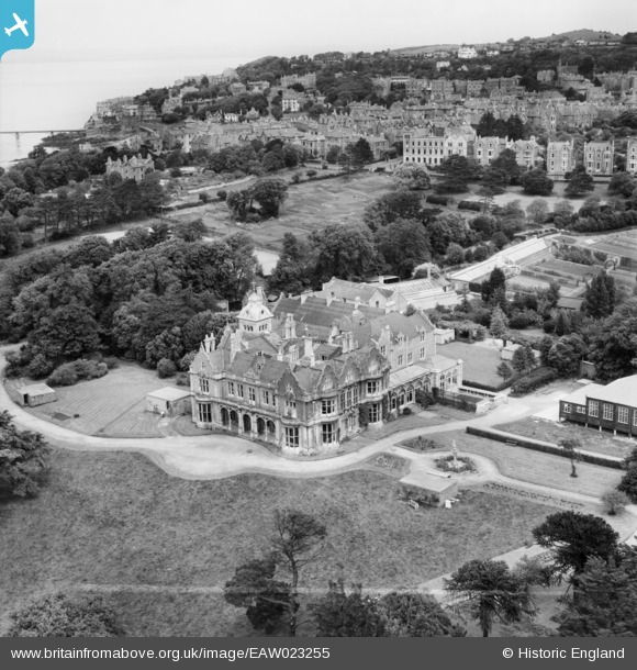
EAW023255 ENGLAND (1949). St Brandon's School (Clevedon Hall), Clevedon, 1949. This image was marked by Aerofilms Ltd for photo editing.
© Hawlfraint cyfranwyr OpenStreetMap a thrwyddedwyd gan yr OpenStreetMap Foundation. 2026. Trwyddedir y gartograffeg fel CC BY-SA.
Delweddau cyfagos (6)
EAW023255
, Clevedon, 1949. This image was marked by Aerofilms Ltd for photo editing.")
EPW024059

EPW033272

EAW023253
 and environs, Clevedon, 1949. This image was marked by Aerofilms Ltd for photo editing.")
EAW023254
 and environs, Clevedon, 1949. This image was marked by Aerofilms Ltd for photo editing.")
EPW024070

Manylion
| Pennawd | [EAW023255] St Brandon's School (Clevedon Hall), Clevedon, 1949. This image was marked by Aerofilms Ltd for photo editing. |
| Cyfeirnod | EAW023255 |
| Dyddiad | 23-May-1949 |
| Dolen | |
| Enw lle | CLEVEDON |
| Plwyf | CLEVEDON |
| Ardal | |
| Gwlad | ENGLAND |
| Dwyreiniad / Gogleddiad | 340057, 171129 |
| Hydred / Lledred | -2.8624466208573, 51.435493878006 |
| Cyfeirnod Grid Cenedlaethol | ST401711 |
Pinnau

Matt Aldred edob.mattaldred.com |
Sunday 2nd of March 2025 10:19:13 PM | |
|
Matt Aldred edob.mattaldred.com |
Sunday 2nd of March 2025 10:19:00 PM | |
|
Matt Aldred edob.mattaldred.com |
Sunday 2nd of March 2025 10:18:44 PM | |
|
Matt Aldred edob.mattaldred.com |
Sunday 2nd of March 2025 10:18:25 PM | |
|
Matt Aldred edob.mattaldred.com |
Sunday 2nd of March 2025 10:18:07 PM | |
|
Matt Aldred edob.mattaldred.com |
Thursday 14th of March 2024 12:08:43 PM | |

Class31 |
Saturday 20th of December 2014 08:36:08 PM |
