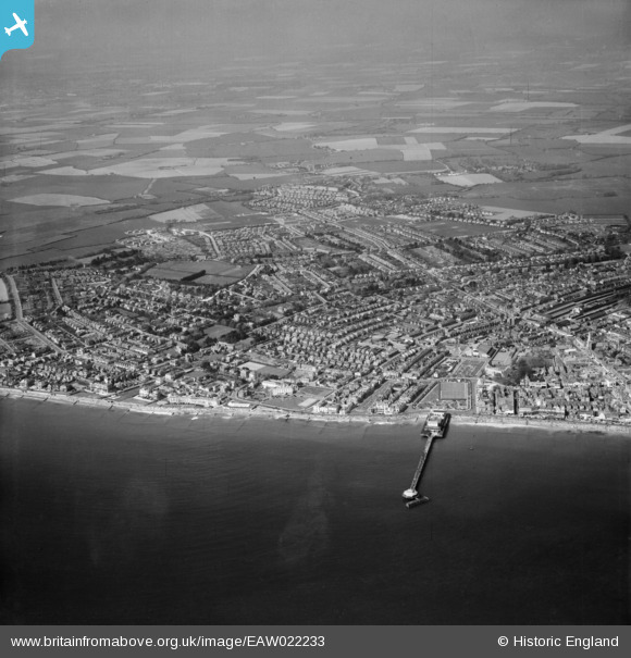
EAW022233 ENGLAND (1949). The Pier and the town, Bognor Regis, from the south-east, 1949
© Hawlfraint cyfranwyr OpenStreetMap a thrwyddedwyd gan yr OpenStreetMap Foundation. 2026. Trwyddedir y gartograffeg fel CC BY-SA.
Delweddau cyfagos (16)
Manylion
| Pennawd | [EAW022233] The Pier and the town, Bognor Regis, from the south-east, 1949 |
| Cyfeirnod | EAW022233 |
| Dyddiad | 17-April-1949 |
| Dolen | |
| Enw lle | BOGNOR REGIS |
| Plwyf | BOGNOR REGIS |
| Ardal | |
| Gwlad | ENGLAND |
| Dwyreiniad / Gogleddiad | 493294, 98659 |
| Hydred / Lledred | -0.67656377854472, 50.779428123969 |
| Cyfeirnod Grid Cenedlaethol | SZ933987 |
Pinnau

Stephen Mirrington |
Wednesday 25th of August 2021 11:23:22 AM | |

Bluid |
Monday 28th of December 2020 10:21:14 AM | |
Shown here after the fire. The right tower missing, and what looks like make-shift repairs. |

Bluid |
Tuesday 7th of January 2014 04:18:00 PM |

Bluid |
Monday 28th of December 2020 10:19:11 AM | |

Bluid |
Saturday 2nd of May 2020 08:50:07 AM | |

Bluid |
Monday 15th of April 2019 10:07:26 AM | |

Bluid |
Saturday 28th of June 2014 07:44:41 PM | |

Bluid |
Friday 13th of June 2014 08:17:27 AM | |

coastal_dweller |
Friday 7th of February 2014 06:56:04 PM | |

Bluid |
Monday 6th of January 2014 09:14:01 PM | |

Bluid |
Monday 6th of January 2014 09:09:43 PM | |

JerryE |
Monday 30th of December 2013 09:14:05 PM | |

JerryE |
Monday 30th of December 2013 09:05:22 PM | |

JerryE |
Monday 30th of December 2013 08:55:13 PM | |

JerryE |
Monday 30th of December 2013 08:53:36 PM | |

JerryE |
Monday 30th of December 2013 08:52:14 PM | |

JerryE |
Monday 30th of December 2013 08:50:48 PM | |

JerryE |
Saturday 28th of December 2013 10:16:34 PM | |
Merchant Taylors [There is a postcard of the rear of this building] see other aerial veiw |

Bluid |
Tuesday 7th of January 2014 01:57:06 AM |

JerryE |
Saturday 28th of December 2013 10:13:32 PM | |

JerryE |
Saturday 28th of December 2013 10:05:27 PM | |

JerryE |
Saturday 28th of December 2013 10:04:35 PM | |
A tragedy, that was a building with Listed status written all over it. |

Bluid |
Tuesday 7th of January 2014 04:19:17 PM |

JerryE |
Saturday 28th of December 2013 10:00:28 PM | |

JerryE |
Saturday 28th of December 2013 09:59:15 PM |


![[EAW022233] The Pier and the town, Bognor Regis, from the south-east, 1949](http://britainfromabove.org.uk/sites/all/libraries/aerofilms-images/public/100x100/EAW/022/EAW022233.jpg)
![[EAW022236] The Pier and the town, Bognor Regis, from the south, 1949](http://britainfromabove.org.uk/sites/all/libraries/aerofilms-images/public/100x100/EAW/022/EAW022236.jpg)
![[EAW046504] The pier and town, Bognor Regis, from the south, 1952](http://britainfromabove.org.uk/sites/all/libraries/aerofilms-images/public/100x100/EAW/046/EAW046504.jpg)
![[EPW040107] Waterloo Square and the town, Bognor Regis, 1932](http://britainfromabove.org.uk/sites/all/libraries/aerofilms-images/public/100x100/EPW/040/EPW040107.jpg)
![[EAW046803] The pier and the town, Bognor Regis, from the south, 1952](http://britainfromabove.org.uk/sites/all/libraries/aerofilms-images/public/100x100/EAW/046/EAW046803.jpg)
![[EPW040096] The Royal Norfolk Hotel, Bognor Regis, 1932](http://britainfromabove.org.uk/sites/all/libraries/aerofilms-images/public/100x100/EPW/040/EPW040096.jpg)
![[EPW040097] The Royal Norfolk Hotel, bandstand and environs, Bognor Regis, 1932](http://britainfromabove.org.uk/sites/all/libraries/aerofilms-images/public/100x100/EPW/040/EPW040097.jpg)
![[EPW040095] The Royal Norfolk Hotel, Bognor Regis, 1932](http://britainfromabove.org.uk/sites/all/libraries/aerofilms-images/public/100x100/EPW/040/EPW040095.jpg)
![[EPW016854] The Royal Norfolk Hotel, Bognor Regis, 1926](http://britainfromabove.org.uk/sites/all/libraries/aerofilms-images/public/100x100/EPW/016/EPW016854.jpg)
![[EPW016907] The Royal Norfolk Hotel, Bognor Regis, 1926](http://britainfromabove.org.uk/sites/all/libraries/aerofilms-images/public/100x100/EPW/016/EPW016907.jpg)
![[EPW000760] Waterloo Square and the Pier, Bognor Regis, 1920](http://britainfromabove.org.uk/sites/all/libraries/aerofilms-images/public/100x100/EPW/000/EPW000760.jpg)
![[EAW046802] Rock Gardens, the Royal Norfolk Hotel and the town, Bognor Regis, from the south-east, 1952](http://britainfromabove.org.uk/sites/all/libraries/aerofilms-images/public/100x100/EAW/046/EAW046802.jpg)
![[EPW040108] The pier and the town, Bognor Regis, from the south, 1932](http://britainfromabove.org.uk/sites/all/libraries/aerofilms-images/public/100x100/EPW/040/EPW040108.jpg)
![[EAW046804] The pier and the town, Bognor Regis, from the east, 1952](http://britainfromabove.org.uk/sites/all/libraries/aerofilms-images/public/100x100/EAW/046/EAW046804.jpg)
![[EPW040100] Marine Drive from the pier to York Road, Bognor Regis, 1932](http://britainfromabove.org.uk/sites/all/libraries/aerofilms-images/public/100x100/EPW/040/EPW040100.jpg)
![[EPW040105] Marine Drive, Bognor Regis, 1932](http://britainfromabove.org.uk/sites/all/libraries/aerofilms-images/public/100x100/EPW/040/EPW040105.jpg)


