
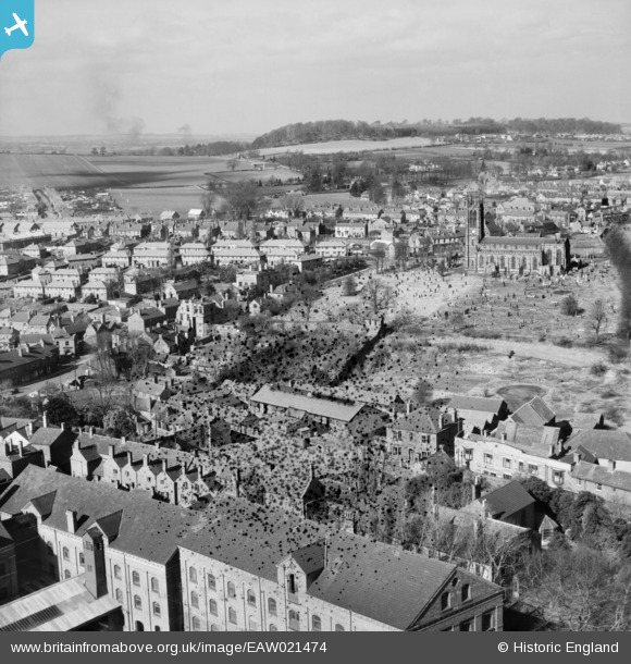
EAW021474 ENGLAND (1949). Holy Trinity Church and buildings along High Street and Brierley Hill Road, Wordsley, from the south-east, 1949. This image has been produced from a damaged negative.
© Hawlfraint cyfranwyr OpenStreetMap a thrwyddedwyd gan yr OpenStreetMap Foundation. 2026. Trwyddedir y gartograffeg fel CC BY-SA.
Delweddau cyfagos (7)
EAW021474

EAW021476

EAW021471

EAW021477

EAW021473

EAW021475

EAW021472

Manylion
| Pennawd | [EAW021474] Holy Trinity Church and buildings along High Street and Brierley Hill Road, Wordsley, from the south-east, 1949. This image has been produced from a damaged negative. |
| Cyfeirnod | EAW021474 |
| Dyddiad | 15-March-1949 |
| Dolen | |
| Enw lle | WORDSLEY |
| Plwyf | |
| Ardal | |
| Gwlad | ENGLAND |
| Dwyreiniad / Gogleddiad | 389331, 286702 |
| Hydred / Lledred | -2.157103268066, 52.477771730801 |
| Cyfeirnod Grid Cenedlaethol | SO893867 |
Pinnau

SirSmilerIV |
Sunday 28th of April 2024 12:37:57 PM | |
|
SirSmilerIV |
Sunday 28th of April 2024 12:37:04 PM | |
|
DKH |
Sunday 5th of February 2023 01:33:48 PM |