Downtime message

Due to planned maintenance taking place on Thursday 9th October between 9:00 AM and 1:00 PM, services might be disrupted or temporarily unavailable. We apologise for any inconvenience.


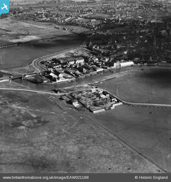
EAW021188 ENGLAND (1949). Electricity Transforming Station, St Oswald's Road and environs, Gloucester, 1949. This image has been produced from a print.

© Hawlfraint cyfranwyr OpenStreetMap a thrwyddedwyd gan yr OpenStreetMap Foundation. 2025. Trwyddedir y gartograffeg fel CC BY-SA.

Delweddau cyfagos (3)

EAW021188
  0° 0m
EAW021186
  178° 245m
EPW038349
  289° 253m

Manylion

Pennawd [EAW021188] Electricity Transforming Station, St Oswald's Road and environs, Gloucester, 1949. This image has been produced from a print.
Cyfeirnod EAW021188
Dyddiad 2-March-1949
Dolen
Enw lle GLOUCESTER
Plwyf
Ardal
Gwlad ENGLAND
Dwyreiniad / Gogleddiad 382442, 218855
Hydred / Lledred -2.2550318934388, 51.86755494925
Cyfeirnod Grid Cenedlaethol SO824189

Pinnau

WW2 Air Raid Shelter

Sparky
Friday 25th of August 2017 09:38:18 PM
St. Nicholas' Church, Westgate Street, Gloucester, 03/06/2015

Class31
Thursday 4th of June 2015 01:57:39 PM
Former St. Bartholomew's Hospital Almshouses, Westgate, Gloucester, 03/06/2015

Class31
Thursday 4th of June 2015 01:56:25 PM
Westgate Bridge, Gloucester, 03/06/2015

Class31
Thursday 4th of June 2015 01:54:41 PM
River Severn, East Channel, Gloucester, 03/06/2015

Class31
Thursday 4th of June 2015 01:53:56 PM

Cyfraniadau Grŵp

Electricity Transforming Station, Castle Meads, Gloucester, 03/06/2015

Class31
Thursday 4th of June 2015 01:53:10 PM
Electricity Transforming Station, Castle Meads, Gloucester, 03/06/2015

Class31
Thursday 4th of June 2015 01:52:42 PM