
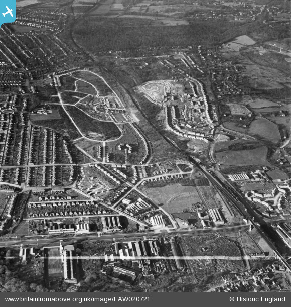
EAW020721 ENGLAND (1948). New housing development around Tillingbourne Green and Ravensbury Road, Poverest, 1948. This image was marked by Aerofilms Ltd for photo editing.
© Hawlfraint cyfranwyr OpenStreetMap a thrwyddedwyd gan yr OpenStreetMap Foundation. 2026. Trwyddedir y gartograffeg fel CC BY-SA.
Delweddau cyfagos (4)
EAW020721

EAW020742

EAW020741

EAW020718

Manylion
| Pennawd | [EAW020721] New housing development around Tillingbourne Green and Ravensbury Road, Poverest, 1948. This image was marked by Aerofilms Ltd for photo editing. |
| Cyfeirnod | EAW020721 |
| Dyddiad | 24-December-1948 |
| Dolen | |
| Enw lle | POVEREST |
| Plwyf | |
| Ardal | |
| Gwlad | ENGLAND |
| Dwyreiniad / Gogleddiad | 546451, 168175 |
| Hydred / Lledred | 0.1052475556847, 51.393190842505 |
| Cyfeirnod Grid Cenedlaethol | TQ465682 |
Pinnau

Matt Aldred edob.mattaldred.com |
Tuesday 8th of April 2025 01:22:33 PM | |

garyb |
Monday 7th of July 2014 10:52:01 PM | |
|
garyb |
Monday 7th of July 2014 10:44:53 PM | |
|
Gone2Kent |
Friday 31st of January 2014 10:45:57 PM |