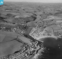
EAW020275 ENGLAND (1948). The harbour and town, Looe, from the south-east, 1948
© Hawlfraint cyfranwyr OpenStreetMap a thrwyddedwyd gan yr OpenStreetMap Foundation. 2026. Trwyddedir y gartograffeg fel CC BY-SA.
Delweddau cyfagos (15)
Manylion
| Pennawd | [EAW020275] The harbour and town, Looe, from the south-east, 1948 |
| Cyfeirnod | EAW020275 |
| Dyddiad | 26-October-1948 |
| Dolen | |
| Enw lle | LOOE |
| Plwyf | LOOE |
| Ardal | |
| Gwlad | ENGLAND |
| Dwyreiniad / Gogleddiad | 225633, 52871 |
| Hydred / Lledred | -4.4511888635775, 50.34928552334 |
| Cyfeirnod Grid Cenedlaethol | SX256529 |
Pinnau

Matt Aldred edob.mattaldred.com |
Tuesday 9th of March 2021 05:15:01 PM | |

redmist |
Wednesday 16th of December 2020 10:28:51 AM | |

redmist |
Wednesday 16th of December 2020 10:28:22 AM | |

redmist |
Wednesday 16th of December 2020 10:26:38 AM | |

redmist |
Wednesday 16th of December 2020 10:25:23 AM | |

redmist |
Tuesday 15th of December 2020 03:27:34 PM | |

redmist |
Tuesday 15th of December 2020 03:23:25 PM | |

redmist |
Tuesday 15th of December 2020 03:15:43 PM | |

redmist |
Tuesday 15th of December 2020 03:13:37 PM | |

Alec K |
Sunday 12th of January 2020 04:26:10 PM | |

Alec K |
Wednesday 11th of December 2019 02:43:11 PM | |

cptpies |
Monday 30th of March 2015 02:17:21 PM | |

cptpies |
Monday 30th of March 2015 02:16:47 PM | |

cptpies |
Monday 30th of March 2015 02:16:01 PM | |

cptpies |
Monday 30th of March 2015 02:15:19 PM | |

clippedwings |
Sunday 20th of April 2014 12:02:07 PM |
Cyfraniadau Grŵp

cptpies |
Monday 30th of March 2015 02:20:03 PM | |
Looe Railway Station, 14/01/2008 |

Class31 |
Monday 22nd of December 2014 03:50:19 PM |
East Looe, 14/01/2008 |

Class31 |
Monday 22nd of December 2014 03:46:44 PM |
The Beach 14/01/2008 |

Class31 |
Wednesday 29th of January 2014 05:30:23 PM |
End of The Pier 14/01/2008 |

Class31 |
Wednesday 29th of January 2014 05:27:34 PM |


![[EAW020275] The harbour and town, Looe, from the south-east, 1948](http://britainfromabove.org.uk/sites/all/libraries/aerofilms-images/public/100x100/EAW/020/EAW020275.jpg)
![[EAW040790] Hotels along Hannafore Road, Looe, 1951. This image has been produced from a print marked by Aerofilms Ltd for photo editing.](http://britainfromabove.org.uk/sites/all/libraries/aerofilms-images/public/100x100/EAW/040/EAW040790.jpg)
![[EAW040785] Hotels along Hannafore Road, Looe, 1951. This image has been produced from a print marked by Aerofilms Ltd for photo editing.](http://britainfromabove.org.uk/sites/all/libraries/aerofilms-images/public/100x100/EAW/040/EAW040785.jpg)
![[EAW040788] Hotels along Hannafore Road, Looe, 1951. This image has been produced from a print marked by Aerofilms Ltd for photo editing.](http://britainfromabove.org.uk/sites/all/libraries/aerofilms-images/public/100x100/EAW/040/EAW040788.jpg)
![[EAW040786] The Fieldhead, Headland and Hannafore Point Hotels, Looe, 1951. This image has been produced from a print marked by Aerofilms Ltd for photo editing.](http://britainfromabove.org.uk/sites/all/libraries/aerofilms-images/public/100x100/EAW/040/EAW040786.jpg)
![[EAW040787] Hotels along Hannafore Road, Looe, 1951. This image has been produced from a print marked by Aerofilms Ltd for photo editing.](http://britainfromabove.org.uk/sites/all/libraries/aerofilms-images/public/100x100/EAW/040/EAW040787.jpg)
![[EAW040784] The Fieldhead, Headland and Hannafore Point Hotels, Looe, 1951. This image has been produced from a print marked by Aerofilms Ltd for photo editing.](http://britainfromabove.org.uk/sites/all/libraries/aerofilms-images/public/100x100/EAW/040/EAW040784.jpg)
![[EAW040789] Hotels along Hannafore Road, Looe, 1951. This image has been produced from a print marked by Aerofilms Ltd for photo editing.](http://britainfromabove.org.uk/sites/all/libraries/aerofilms-images/public/100x100/EAW/040/EAW040789.jpg)
![[EAW020247] Nailzee Point Hotel, Looe, 1948. This image has been produced from a print marked by Aerofilms Ltd for photo editing.](http://britainfromabove.org.uk/sites/all/libraries/aerofilms-images/public/100x100/EAW/020/EAW020247.jpg)
![[EAW051358] The town, Looe, from the south-east, 1953](http://britainfromabove.org.uk/sites/all/libraries/aerofilms-images/public/100x100/EAW/051/EAW051358.jpg)
![[EAW020250] Nailzee Point Hotel, Looe, 1948. This image has been produced from a print marked by Aerofilms Ltd for photo editing.](http://britainfromabove.org.uk/sites/all/libraries/aerofilms-images/public/100x100/EAW/020/EAW020250.jpg)
![[EAW020248] Nailzee Point Hotel, Looe, from the east, 1948. This image has been produced from a print marked by Aerofilms Ltd for photo editing.](http://britainfromabove.org.uk/sites/all/libraries/aerofilms-images/public/100x100/EAW/020/EAW020248.jpg)
![[EAW020246] Nailzee Point Hotel, Looe, from the east, 1948. This image has been produced from a print.](http://britainfromabove.org.uk/sites/all/libraries/aerofilms-images/public/100x100/EAW/020/EAW020246.jpg)
![[EAW021374] Looe Bay, the harbour and the town, Looe, from the south-east, 1949. This image has been produced from a print.](http://britainfromabove.org.uk/sites/all/libraries/aerofilms-images/public/100x100/EAW/021/EAW021374.jpg)
![[EAW020249] Nailzee Point Hotel, Looe, from the east, 1948. This image has been produced from a print.](http://britainfromabove.org.uk/sites/all/libraries/aerofilms-images/public/100x100/EAW/020/EAW020249.jpg)
