
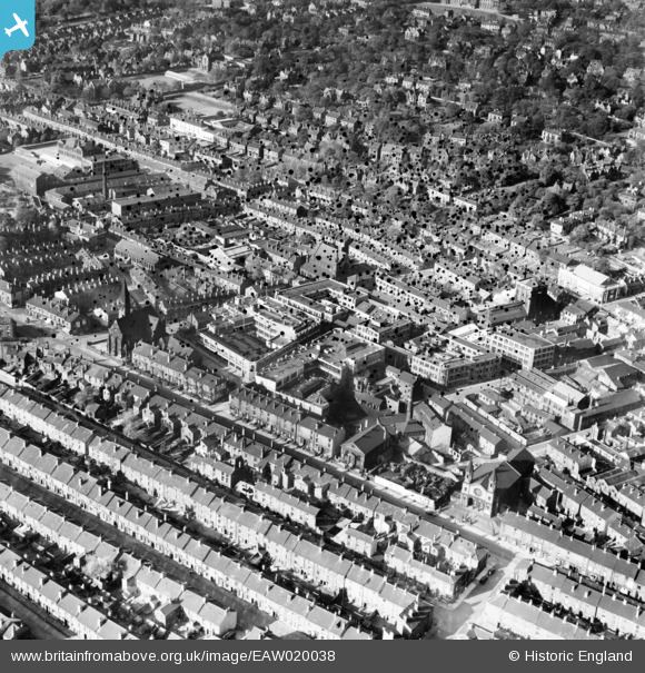
EAW020038 ENGLAND (1948). Works off Cemetery Road and Napier Street, Sheffield, 1948. This image has been produced from a damaged negative.
© Hawlfraint cyfranwyr OpenStreetMap a thrwyddedwyd gan yr OpenStreetMap Foundation. 2026. Trwyddedir y gartograffeg fel CC BY-SA.
Delweddau cyfagos (48)
EAW020038

EAW018794

EAW018797

EAW020040

EAW018796

EAW018795

EAW018793

EPW047985

EAW047704
 Ltd Composite Steel Works and environs, Sheffield, 1952. This image was marked by Aerofilms Ltd for photo editing.")
EPW047982

EPW047984

EPW047986

EPW047987

EAW020035

EAW006274

EAW048671

EAW006277

EAW020036

EAW048670

EAW048666

EAW048667

EAW006271

EAW006275

EAW048668

EAW047705
 Ltd Composite Steel Works and the city centre, Sheffield, from the south, 1952. This image was marked by Aerofilms Ltd for photo editing.")
EAW047703
 Ltd Composite Steel Works and environs, Sheffield, 1952. This image was marked by Aerofilms Ltd for photo editing.")
EAW020037
, Washington Road and environs, Sheffield, 1948. This image has been produced from a damaged negative.")
EAW048665

EAW047709
 Ltd Composite Steel Works and environs, Sheffield, 1952. This image was marked by Aerofilms Ltd for photo editing.")
EAW048672

EAW006272

EAW006279

EAW006273

EAW047707
 Ltd Composite Steel Works and environs, Sheffield, 1952. This image was marked by Aerofilms Ltd for photo editing.")
EAW048664

EAW047706
 Ltd Composite Steel Works and environs, Sheffield, 1952. This image was marked by Aerofilms Ltd for photo editing.")
EAW047708
 Ltd Composite Steel Works and the city centre, Sheffield, from the south-west, 1952. This image was marked by Aerofilms Ltd for photo editing.")
EAW047710
 Ltd Composite Steel Works and environs, Sheffield, 1952. This image was marked by Aerofilms Ltd for photo editing.")
EAW048669

EAW006278

EAW006276

EAW047711A
 Ltd Composite Steel Works and environs, Sheffield, from the south-west, 1952. This image was marked by Aerofilms Ltd for photo editing.")
EAW005021

EAW005022

EAW005027

EAW005023

EAW005025

EAW005026

Manylion
| Pennawd | [EAW020038] Works off Cemetery Road and Napier Street, Sheffield, 1948. This image has been produced from a damaged negative. |
| Cyfeirnod | EAW020038 |
| Dyddiad | 19-October-1948 |
| Dolen | |
| Enw lle | SHEFFIELD |
| Plwyf | |
| Ardal | |
| Gwlad | ENGLAND |
| Dwyreiniad / Gogleddiad | 434542, 386196 |
| Hydred / Lledred | -1.4807795555714, 53.371230934907 |
| Cyfeirnod Grid Cenedlaethol | SK345862 |
Pinnau

redmist |
Tuesday 27th of August 2019 09:39:10 AM | |
|
dawn19run |
Tuesday 24th of December 2013 10:47:31 PM | |
|
dawn19run |
Tuesday 24th of December 2013 10:45:16 PM | |
|
dawn19run |
Tuesday 24th of December 2013 10:43:55 PM | |
|
dawn19run |
Tuesday 24th of December 2013 10:43:00 PM | |
|
dawn19run |
Tuesday 24th of December 2013 10:41:24 PM | |
|
dawn19run |
Tuesday 24th of December 2013 10:40:39 PM | |
|
dawn19run |
Tuesday 24th of December 2013 10:36:25 PM | |
|
dawn19run |
Tuesday 24th of December 2013 10:35:00 PM | |
|
dawn19run |
Tuesday 24th of December 2013 10:34:19 PM | |
|
dawn19run |
Tuesday 24th of December 2013 10:32:16 PM | |
|
dawn19run |
Tuesday 24th of December 2013 10:30:12 PM | |
|
dawn19run |
Tuesday 24th of December 2013 10:27:47 PM | |
|
dawn19run |
Tuesday 24th of December 2013 10:26:29 PM | |
|
dawn19run |
Tuesday 24th of December 2013 10:25:15 PM | |
|
dawn19run |
Friday 20th of December 2013 01:02:02 PM |