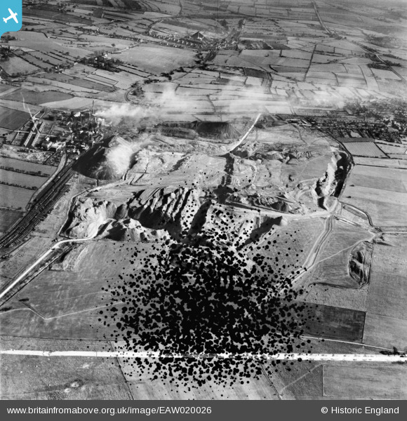
EAW020026 ENGLAND (1948). Fordbridge Meadow Opencast Coal Site, South Normanton, 1948. This image has been produced from a damaged negative.
    © Hawlfraint cyfranwyr OpenStreetMap a thrwyddedwyd gan yr OpenStreetMap Foundation. 2025. Trwyddedir y gartograffeg fel CC BY-SA.
  
Delweddau cyfagos (8)
Manylion
| Pennawd | [EAW020026] Fordbridge Meadow Opencast Coal Site, South Normanton, 1948. This image has been produced from a damaged negative. | 
| Cyfeirnod | EAW020026 | 
| Dyddiad | 19-October-1948 | 
| Dolen | |
| Enw lle | SOUTH NORMANTON | 
| Plwyf | SOUTH NORMANTON | 
| Ardal | |
| Gwlad | ENGLAND | 
| Dwyreiniad / Gogleddiad | 443558, 357344 | 
| Hydred / Lledred | -1.3492100107719, 53.111206196979 | 
| Cyfeirnod Grid Cenedlaethol | SK436573 | 
Pinnau
|  Blackwell Colliery. |   Spartanhouse | Friday 18th of February 2022 12:22:18 AM | 
|  Blackwell Colliery. |   Spartanhouse | Friday 18th of February 2022 12:20:55 AM | 
|  Blackwell colliery |   dd1000 | Thursday 18th of July 2019 02:18:20 PM | 
|   dd1000 | Thursday 18th of July 2019 02:16:34 PM | |
|  The Shoulder of Mutton public house, South Normanton |   dd1000 | Thursday 18th of July 2019 02:04:04 PM | 
|  St Michael & All Angels Church, South Normanton |   dd1000 | Thursday 18th of July 2019 01:48:53 PM | 
|  Fordbridge Mill, Fordbridge Lane, South Normanton, formally a tower windmill for grinding corn, later used as a water tank, then converted to a house. |   dd1000 | Thursday 18th of July 2019 01:45:00 PM | 
 
             
  ![[EAW020026] Fordbridge Meadow Opencast Coal Site, South Normanton, 1948. This image has been produced from a damaged negative.](http://britainfromabove.org.uk/sites/all/libraries/aerofilms-images/public/100x100/EAW/020/EAW020026.jpg) 
  
                                          ![[EAW020025] Fordbridge Meadow Opencast Coal Site (site of), South Normanton, 1948. This image has been produced from a damaged negative.](http://britainfromabove.org.uk/sites/all/libraries/aerofilms-images/public/100x100/EAW/020/EAW020025.jpg) 
 ![[EAW020027] Fordbridge Meadow Opencast Coal Site, South Normanton, 1948. This image has been produced from a damaged negative.](http://britainfromabove.org.uk/sites/all/libraries/aerofilms-images/public/100x100/EAW/020/EAW020027.jpg) 
 ![[EAW020028] Fordbridge Meadow Opencast Coal Site, South Normanton, 1948. This image has been produced from a print.](http://britainfromabove.org.uk/sites/all/libraries/aerofilms-images/public/100x100/EAW/020/EAW020028.jpg) 
 ![[EAW020029] Fordbridge Meadow Opencast Coal Site, South Normanton, 1948. This image has been produced from a print marked by Aerofilms Ltd for photo editing.](http://britainfromabove.org.uk/sites/all/libraries/aerofilms-images/public/100x100/EAW/020/EAW020029.jpg) 
 ![[EAW020031] Fordbridge Meadow Opencast Coal Site, South Normanton, 1948. This image has been produced from a print marked by Aerofilms Ltd for photo editing.](http://britainfromabove.org.uk/sites/all/libraries/aerofilms-images/public/100x100/EAW/020/EAW020031.jpg) 
 ![[EAW020030] Fordbridge Meadow Opencast Coal Site, South Normanton, 1948. This image has been produced from a print.](http://britainfromabove.org.uk/sites/all/libraries/aerofilms-images/public/100x100/EAW/020/EAW020030.jpg) 
 ![[EAW020032] Fordbridge Meadow Opencast Coal Site, South Normanton, 1948. This image has been produced from a print marked by Aerofilms Ltd for photo editing.](http://britainfromabove.org.uk/sites/all/libraries/aerofilms-images/public/100x100/EAW/020/EAW020032.jpg) 
 
