
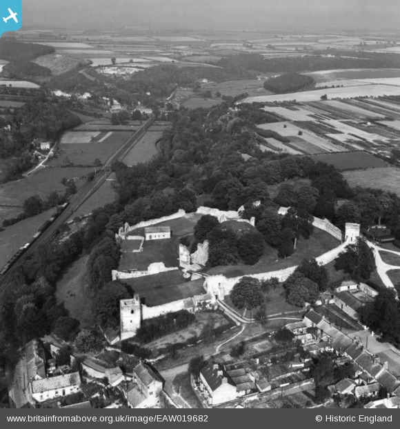
EAW019682 ENGLAND (1948). Pickering Castle, Pickering, from the south, 1948. This image has been produced from a print.
© Hawlfraint cyfranwyr OpenStreetMap a thrwyddedwyd gan yr OpenStreetMap Foundation. 2026. Trwyddedir y gartograffeg fel CC BY-SA.
Delweddau cyfagos (20)
EAW019682

EAW005712

EAW005709

EAW019685

EAW052023

EAW019683

EAW019684

EAW050707

EAW019681

EAW005713

EPW029532

EAW005711

EAW050708

EAW005714

EAW050710

EAW052022

EAW005710

EAW052021

EAW050709

EAW005715

Manylion
| Pennawd | [EAW019682] Pickering Castle, Pickering, from the south, 1948. This image has been produced from a print. |
| Cyfeirnod | EAW019682 |
| Dyddiad | 6-October-1948 |
| Dolen | |
| Enw lle | PICKERING |
| Plwyf | PICKERING |
| Ardal | |
| Gwlad | ENGLAND |
| Dwyreiniad / Gogleddiad | 479812, 484459 |
| Hydred / Lledred | -0.77493535628721, 54.249420626765 |
| Cyfeirnod Grid Cenedlaethol | SE798845 |
Pinnau

totoro |
Tuesday 23rd of December 2014 04:53:23 PM | |
|
totoro |
Tuesday 23rd of December 2014 04:52:33 PM | |
|
totoro |
Tuesday 23rd of December 2014 04:51:59 PM | |
|
totoro |
Tuesday 23rd of December 2014 04:51:26 PM | |
|
totoro |
Tuesday 23rd of December 2014 04:50:50 PM | |
|
totoro |
Tuesday 23rd of December 2014 04:50:09 PM |
Cyfraniadau Grŵp

A timber motte and bailey castle was built on this site by William the Conqueror in 1069-70, after the 'harrying of the North'. It rebuilt in stone between 1180 and 1236. |
Cat |
Monday 29th of September 2014 09:35:15 AM |