
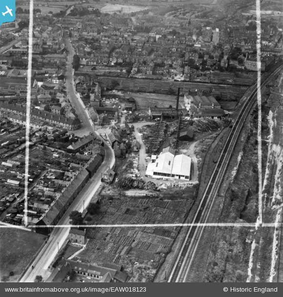
EAW018123 ENGLAND (1948). Godley and Goulding Timber Yard and Saw Mill and environs, Worksop, 1948. This image has been produced from a print marked by Aerofilms Ltd for photo editing.
© Hawlfraint cyfranwyr OpenStreetMap a thrwyddedwyd gan yr OpenStreetMap Foundation. 2026. Trwyddedir y gartograffeg fel CC BY-SA.
Delweddau cyfagos (18)
EAW018123

EPW041462

EPW041458

EPW041461

EPW041455

EAW018124

EPW041460

EPW041456

EAW018117

EAW018122

EPW041459

EAW018119

EAW018120

EAW018125

EAW018118

EAW018121

EAW018116

EPW041457

Manylion
| Pennawd | [EAW018123] Godley and Goulding Timber Yard and Saw Mill and environs, Worksop, 1948. This image has been produced from a print marked by Aerofilms Ltd for photo editing. |
| Cyfeirnod | EAW018123 |
| Dyddiad | 11-August-1948 |
| Dolen | |
| Enw lle | WORKSOP |
| Plwyf | |
| Ardal | |
| Gwlad | ENGLAND |
| Dwyreiniad / Gogleddiad | 459085, 379499 |
| Hydred / Lledred | -1.1131480835484, 53.308859652176 |
| Cyfeirnod Grid Cenedlaethol | SK591795 |
Pinnau
Byddwch y cyntaf i ychwanegu sylw at y ddelwedd hon!