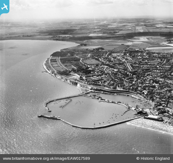
EAW017589 ENGLAND (1948). The Royal Harbour and part of the town, Ramsgate, 1948. This image has been produced from a print.
© Hawlfraint cyfranwyr OpenStreetMap a thrwyddedwyd gan yr OpenStreetMap Foundation. 2026. Trwyddedir y gartograffeg fel CC BY-SA.
Delweddau cyfagos (27)
Manylion
| Pennawd | [EAW017589] The Royal Harbour and part of the town, Ramsgate, 1948. This image has been produced from a print. |
| Cyfeirnod | EAW017589 |
| Dyddiad | 22-July-1948 |
| Dolen | |
| Enw lle | RAMSGATE |
| Plwyf | RAMSGATE |
| Ardal | |
| Gwlad | ENGLAND |
| Dwyreiniad / Gogleddiad | 638576, 164477 |
| Hydred / Lledred | 1.4250208351761, 51.328755008776 |
| Cyfeirnod Grid Cenedlaethol | TR386645 |
Pinnau

Alan McFaden |
Thursday 28th of August 2014 09:37:25 AM | |

Alan McFaden |
Thursday 28th of August 2014 09:36:37 AM | |

Alan McFaden |
Thursday 28th of August 2014 09:35:54 AM |


![[EAW017589] The Royal Harbour and part of the town, Ramsgate, 1948. This image has been produced from a print.](http://britainfromabove.org.uk/sites/all/libraries/aerofilms-images/public/100x100/EAW/017/EAW017589.jpg)
![[EAW008999] Royal Harbour and the town, Ramsgate, 1947](http://britainfromabove.org.uk/sites/all/libraries/aerofilms-images/public/100x100/EAW/008/EAW008999.jpg)
![[EPW048858] The Royal Harbour, Ramsgate, 1935](http://britainfromabove.org.uk/sites/all/libraries/aerofilms-images/public/100x100/EPW/048/EPW048858.jpg)
![[EPW000600] The Royal Harbour and The Basin, Ramsgate, 1920](http://britainfromabove.org.uk/sites/all/libraries/aerofilms-images/public/100x100/EPW/000/EPW000600.jpg)
![[EAW020486] The town and harbour, Ramsgate, from the east, 1948](http://britainfromabove.org.uk/sites/all/libraries/aerofilms-images/public/100x100/EAW/020/EAW020486.jpg)
![[EPW018646] The Royal Harbour and Harbour Parade, Ramsgate, 1927](http://britainfromabove.org.uk/sites/all/libraries/aerofilms-images/public/100x100/EPW/018/EPW018646.jpg)
![[EAW009050] East Pier, Ramsgate Sands and the town, Ramsgate, 1947](http://britainfromabove.org.uk/sites/all/libraries/aerofilms-images/public/100x100/EAW/009/EAW009050.jpg)
![[EPW000596] The Royal Harbour, Ramsgate, 1920](http://britainfromabove.org.uk/sites/all/libraries/aerofilms-images/public/100x100/EPW/000/EPW000596.jpg)
![[EAW020487] The town and harbour, Ramsgate, from the south-east, 1948](http://britainfromabove.org.uk/sites/all/libraries/aerofilms-images/public/100x100/EAW/020/EAW020487.jpg)
![[EPW039353] Ramsgate Sands, Wellington Crescent and environs, Ramsgate, from the south, 1932](http://britainfromabove.org.uk/sites/all/libraries/aerofilms-images/public/100x100/EPW/039/EPW039353.jpg)
![[EAW009009] Royal Harbour and the town, Ramsgate, 1947](http://britainfromabove.org.uk/sites/all/libraries/aerofilms-images/public/100x100/EAW/009/EAW009009.jpg)
![[EPW035449] The Royal Harbour and environs, Ramsgate, 1931](http://britainfromabove.org.uk/sites/all/libraries/aerofilms-images/public/100x100/EPW/035/EPW035449.jpg)
![[EAW009007] Royal Harbour and the town, Ramsgate, 1947](http://britainfromabove.org.uk/sites/all/libraries/aerofilms-images/public/100x100/EAW/009/EAW009007.jpg)
![[EPW039354] The Royal Harbour and Basin, Ramsgate, 1932](http://britainfromabove.org.uk/sites/all/libraries/aerofilms-images/public/100x100/EPW/039/EPW039354.jpg)
![[EAW009006] Royal Harbour and the town, Ramsgate, 1947](http://britainfromabove.org.uk/sites/all/libraries/aerofilms-images/public/100x100/EAW/009/EAW009006.jpg)
![[EPW042864] The Royal Harbour and the town, Ramsgate, 1933](http://britainfromabove.org.uk/sites/all/libraries/aerofilms-images/public/100x100/EPW/042/EPW042864.jpg)
![[EPW018650] The Royal Harbour and basin, Ramsgate, 1927](http://britainfromabove.org.uk/sites/all/libraries/aerofilms-images/public/100x100/EPW/018/EPW018650.jpg)
![[EAW015836] Royal Harbour, Ramsgate, 1948. This image has been produced from a print.](http://britainfromabove.org.uk/sites/all/libraries/aerofilms-images/public/100x100/EAW/015/EAW015836.jpg)
![[EAW009008] Royal Harbour and the town, Ramsgate, 1947](http://britainfromabove.org.uk/sites/all/libraries/aerofilms-images/public/100x100/EAW/009/EAW009008.jpg)
![[EPW000092] The Clock Tower, Ramsgate Harbour, Ramsgate 1920](http://britainfromabove.org.uk/sites/all/libraries/aerofilms-images/public/100x100/EPW/000/EPW000092.jpg)
![[EPW042861] The East Pier, Ramsgate Sands, Wellington Crescent and the town, Ramsgate, from the south, 1933](http://britainfromabove.org.uk/sites/all/libraries/aerofilms-images/public/100x100/EPW/042/EPW042861.jpg)
![[EAW017592] The Royal Harbour and town, Ramsgate, from the south, 1948. This image has been produced from a print.](http://britainfromabove.org.uk/sites/all/libraries/aerofilms-images/public/100x100/EAW/017/EAW017592.jpg)
![[EPW042862] The Royal Harbour and the town, Ramsgate, from the south, 1933](http://britainfromabove.org.uk/sites/all/libraries/aerofilms-images/public/100x100/EPW/042/EPW042862.jpg)
![[EAW009055] Ramsgate Sands, the Ramsgate Olympia and the town, Ramsgate, from the south-east, 1947](http://britainfromabove.org.uk/sites/all/libraries/aerofilms-images/public/100x100/EAW/009/EAW009055.jpg)
![[EPW000375] Ramsgate Harbour, Ramsgate, 1920](http://britainfromabove.org.uk/sites/all/libraries/aerofilms-images/public/100x100/EPW/000/EPW000375.jpg)
![[EPW000595] The Royal Harbour, Ramsgate, from the south-west, 1920](http://britainfromabove.org.uk/sites/all/libraries/aerofilms-images/public/100x100/EPW/000/EPW000595.jpg)
![[EAW015835] The town and seafront, Ramsgate, 1948. This image has been produced from a print.](http://britainfromabove.org.uk/sites/all/libraries/aerofilms-images/public/100x100/EAW/015/EAW015835.jpg)


