
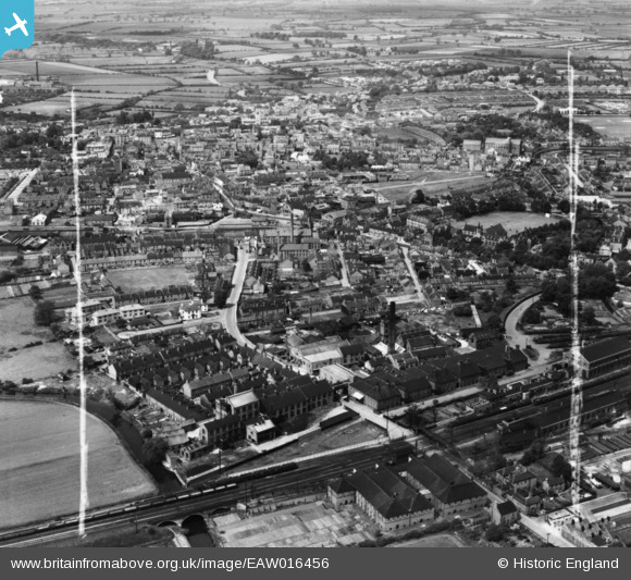
EAW016456 ENGLAND (1948). South Retford, Retford, from the south, 1948. This image has been produced from a print marked by Aerofilms Ltd for photo editing..
© Hawlfraint cyfranwyr OpenStreetMap a thrwyddedwyd gan yr OpenStreetMap Foundation. 2026. Trwyddedir y gartograffeg fel CC BY-SA.
Delweddau cyfagos (8)
EAW016456

EAW016458

EAW016454

EAW016457

EAW016455

EAW016452

EAW016451

EAW016453

Manylion
| Pennawd | [EAW016456] South Retford, Retford, from the south, 1948. This image has been produced from a print marked by Aerofilms Ltd for photo editing.. |
| Cyfeirnod | EAW016456 |
| Dyddiad | 9-June-1948 |
| Dolen | |
| Enw lle | RETFORD |
| Plwyf | |
| Ardal | |
| Gwlad | ENGLAND |
| Dwyreiniad / Gogleddiad | 470650, 380373 |
| Hydred / Lledred | -0.93939536416988, 53.315298755733 |
| Cyfeirnod Grid Cenedlaethol | SK707804 |
Pinnau

Matt Aldred edob.mattaldred.com |
Thursday 20th of March 2025 12:09:20 PM | |

NottmJas |
Monday 29th of January 2024 11:24:36 AM | |
|
NottmJas |
Monday 29th of January 2024 11:24:36 AM | |
|
NottmJas |
Monday 29th of January 2024 11:24:32 AM | |
|
redmist |
Tuesday 19th of April 2022 09:53:34 PM | |
|
redmist |
Tuesday 19th of April 2022 09:53:12 PM | |
|
redmist |
Tuesday 19th of April 2022 09:52:08 PM | |
|
redmist |
Tuesday 19th of April 2022 09:51:22 PM | |
|
redmist |
Tuesday 19th of April 2022 09:50:58 PM | |
|
Ian D |
Sunday 20th of December 2020 09:15:47 PM | |
|
kgs |
Wednesday 15th of February 2017 03:42:55 PM |