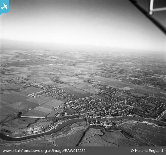
EAW012232 ENGLAND (1947). The River Arun and the town, Littlehampton, from the south-west, 1947
© Hawlfraint cyfranwyr OpenStreetMap a thrwyddedwyd gan yr OpenStreetMap Foundation. 2026. Trwyddedir y gartograffeg fel CC BY-SA.
Manylion
| Pennawd | [EAW012232] The River Arun and the town, Littlehampton, from the south-west, 1947 |
| Cyfeirnod | EAW012232 |
| Dyddiad | 24-November-1947 |
| Dolen | |
| Enw lle | LITTLEHAMPTON |
| Plwyf | LITTLEHAMPTON |
| Ardal | |
| Gwlad | ENGLAND |
| Dwyreiniad / Gogleddiad | 502342, 102390 |
| Hydred / Lledred | -0.54721430024728, 50.811445842162 |
| Cyfeirnod Grid Cenedlaethol | TQ023024 |
Pinnau

redmist |
Friday 14th of March 2025 12:05:18 AM | |

redmist |
Thursday 13th of March 2025 11:59:24 PM | |

redmist |
Thursday 13th of March 2025 11:57:02 PM | |

redmist |
Thursday 13th of March 2025 11:53:47 PM | |

redmist |
Thursday 13th of March 2025 11:52:21 PM | |

redmist |
Thursday 13th of March 2025 11:51:43 PM | |

redmist |
Thursday 13th of March 2025 11:48:10 PM | |

Linny |
Thursday 4th of May 2023 08:54:42 AM | |

Linny |
Thursday 4th of May 2023 08:53:17 AM | |

redmist |
Monday 27th of June 2022 10:42:30 PM | |

redmist |
Monday 27th of June 2022 10:37:17 PM | |

Sparky |
Saturday 30th of September 2017 09:46:45 PM | |

Sparky |
Saturday 30th of September 2017 09:45:51 PM | |

Sparky |
Saturday 30th of September 2017 09:45:13 PM | |

JerryE |
Sunday 29th of December 2013 01:28:01 PM | |

JerryE |
Sunday 29th of December 2013 01:25:45 PM |


![[EAW012232] The River Arun and the town, Littlehampton, from the south-west, 1947](http://britainfromabove.org.uk/sites/all/libraries/aerofilms-images/public/100x100/EAW/012/EAW012232.jpg)
![[EPW039463] The town alongside the River Arun, Littlehampton, 1932](http://britainfromabove.org.uk/sites/all/libraries/aerofilms-images/public/100x100/EPW/039/EPW039463.jpg)
![[EPW017754] Swing bridge over the River Arun and environs, Littlehampton, from the north-west, 1927](http://britainfromabove.org.uk/sites/all/libraries/aerofilms-images/public/100x100/EPW/017/EPW017754.jpg)
![[EPW017753] Swing bridge over the River Arun and environs, Littlehampton, from the south-west, 1927. Double-exposed negative.](http://britainfromabove.org.uk/sites/all/libraries/aerofilms-images/public/100x100/EPW/017/EPW017753.jpg)