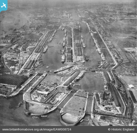
EAW008724 ENGLAND (1947). The Royal Albert Dock and the King George V Dock, North Woolwich, 1947
© Hawlfraint cyfranwyr OpenStreetMap a thrwyddedwyd gan yr OpenStreetMap Foundation. 2026. Trwyddedir y gartograffeg fel CC BY-SA.
Delweddau cyfagos (15)
Manylion
| Pennawd | [EAW008724] The Royal Albert Dock and the King George V Dock, North Woolwich, 1947 |
| Cyfeirnod | EAW008724 |
| Dyddiad | 8-August-1947 |
| Dolen | |
| Enw lle | NORTH WOOLWICH |
| Plwyf | |
| Ardal | |
| Gwlad | ENGLAND |
| Dwyreiniad / Gogleddiad | 543580, 180411 |
| Hydred / Lledred | 0.06897173705666, 51.503886381982 |
| Cyfeirnod Grid Cenedlaethol | TQ436804 |
Pinnau

redmist |
Monday 29th of June 2020 08:08:51 PM | |

redmist |
Monday 29th of June 2020 08:08:14 PM | |

redmist |
Monday 29th of June 2020 08:05:32 PM | |

redmist |
Monday 29th of June 2020 08:04:58 PM |


![[EAW008724] The Royal Albert Dock and the King George V Dock, North Woolwich, 1947](http://britainfromabove.org.uk/sites/all/libraries/aerofilms-images/public/100x100/EAW/008/EAW008724.jpg)
![[EAW014133] King George V Dock and Royal Albert Dock, North Woolwich, from the east, 1948. This image has been produced from a print.](http://britainfromabove.org.uk/sites/all/libraries/aerofilms-images/public/100x100/EAW/014/EAW014133.jpg)
![[EAW008728] The Royal Albert Dock and the King George V Dock, North Woolwich, 1947](http://britainfromabove.org.uk/sites/all/libraries/aerofilms-images/public/100x100/EAW/008/EAW008728.jpg)
![[EAW022358] The Royal Albert and King George V Docks and environs, North Woolwich, from the east, 1949](http://britainfromabove.org.uk/sites/all/libraries/aerofilms-images/public/100x100/EAW/022/EAW022358.jpg)
![[EPW008885] King George V Dock and the Royal Albert Dock, North Woolwich, 1923](http://britainfromabove.org.uk/sites/all/libraries/aerofilms-images/public/100x100/EPW/008/EPW008885.jpg)
![[EAW005290] The Royal Albert Dock, King George V Dock and environs, North Woolwich, from the east, 1947](http://britainfromabove.org.uk/sites/all/libraries/aerofilms-images/public/100x100/EAW/005/EAW005290.jpg)
![[EAW008722] The Royal Albert Dock and the King George V Dock, North Woolwich, 1947](http://britainfromabove.org.uk/sites/all/libraries/aerofilms-images/public/100x100/EAW/008/EAW008722.jpg)
![[EAW008723] The Royal Albert Dock and the King George V Dock, North Woolwich, 1947](http://britainfromabove.org.uk/sites/all/libraries/aerofilms-images/public/100x100/EAW/008/EAW008723.jpg)
![[EPW044121] The Royal Group of Docks, East Ham, from the east, 1934](http://britainfromabove.org.uk/sites/all/libraries/aerofilms-images/public/100x100/EPW/044/EPW044121.jpg)
![[EPW008887] King George V Dock and the Royal Albert Dock, North Woolwich, 1923. This image has been produced from a print.](http://britainfromabove.org.uk/sites/all/libraries/aerofilms-images/public/100x100/EPW/008/EPW008887.jpg)
![[EPW032935] The Royal Albert Dock and King George V Dock, North Woolwich, 1930](http://britainfromabove.org.uk/sites/all/libraries/aerofilms-images/public/100x100/EPW/032/EPW032935.jpg)
![[EAW008740] The Harland and Wolff Ltd Works and the Royal Albert Dock and the King George V Dock, North Woolwich, 1947](http://britainfromabove.org.uk/sites/all/libraries/aerofilms-images/public/100x100/EAW/008/EAW008740.jpg)
![[EAW000051] The King George V Dock and the Royal Albert Dock, Beckton, 1946](http://britainfromabove.org.uk/sites/all/libraries/aerofilms-images/public/100x100/EAW/000/EAW000051.jpg)
![[EAW000055] The King George V Dock and the Royal Albert Dock, Beckton, 1946](http://britainfromabove.org.uk/sites/all/libraries/aerofilms-images/public/100x100/EAW/000/EAW000055.jpg)
![[EAW016657] The Royal Albert Dock, King George V Dock, River Thames and environs, North Woolwich, from the north-west, 1948](http://britainfromabove.org.uk/sites/all/libraries/aerofilms-images/public/100x100/EAW/016/EAW016657.jpg)