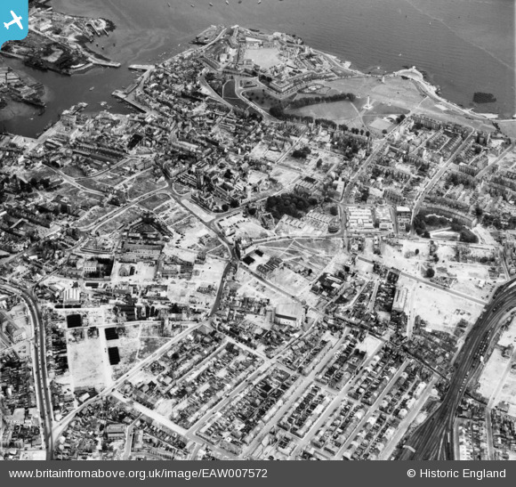
EAW007572 ENGLAND (1947). The city centre, Plymouth, 1947
© Hawlfraint cyfranwyr OpenStreetMap a thrwyddedwyd gan yr OpenStreetMap Foundation. 2026. Trwyddedir y gartograffeg fel CC BY-SA.
Delweddau cyfagos (6)
Manylion
| Pennawd | [EAW007572] The city centre, Plymouth, 1947 |
| Cyfeirnod | EAW007572 |
| Dyddiad | 25-June-1947 |
| Dolen | |
| Enw lle | PLYMOUTH |
| Plwyf | |
| Ardal | |
| Gwlad | ENGLAND |
| Dwyreiniad / Gogleddiad | 247731, 54441 |
| Hydred / Lledred | -4.1414253373762, 50.369527668548 |
| Cyfeirnod Grid Cenedlaethol | SX477544 |
Pinnau

Terry Harris-Layne |
Thursday 22nd of August 2024 05:54:18 PM | |

Terry Harris-Layne |
Thursday 22nd of August 2024 05:51:25 PM | |

Terry Harris-Layne |
Thursday 22nd of August 2024 05:50:13 PM | |

Terry Harris-Layne |
Thursday 22nd of August 2024 05:48:17 PM | |

Jaytaylor |
Monday 21st of February 2022 02:38:13 PM | |

Jaytaylor |
Monday 21st of February 2022 02:37:30 PM | |

Jaytaylor |
Monday 21st of February 2022 02:36:07 PM | |

Jaytaylor |
Monday 21st of February 2022 02:33:55 PM | |

Jaytaylor |
Monday 21st of February 2022 02:33:05 PM | |

Jaytaylor |
Monday 21st of February 2022 02:30:18 PM | |

redmist |
Tuesday 15th of December 2020 02:11:42 PM | |

peterjt |
Saturday 31st of October 2020 10:47:10 AM | |

peterjt |
Thursday 22nd of October 2020 04:08:19 PM | |

peterjt |
Thursday 22nd of October 2020 04:04:05 PM | |

peterjt |
Thursday 22nd of October 2020 04:02:37 PM | |

peterjt |
Thursday 22nd of October 2020 04:01:14 PM | |

peterjt |
Thursday 22nd of October 2020 04:00:02 PM | |

peterjt |
Thursday 22nd of October 2020 03:58:23 PM | |

peterjt |
Thursday 22nd of October 2020 03:50:07 PM | |

peterjt |
Thursday 22nd of October 2020 03:48:17 PM | |

peterjt |
Thursday 22nd of October 2020 03:46:14 PM | |

peterjt |
Thursday 22nd of October 2020 03:45:08 PM | |

Wombateer |
Friday 12th of June 2020 08:27:20 PM | |

Wombateer |
Friday 12th of June 2020 08:25:10 PM | |

Paul |
Saturday 12th of October 2019 05:50:39 PM | |

flyman |
Friday 22nd of September 2017 11:24:28 PM | |

Sparky |
Wednesday 2nd of August 2017 04:22:23 PM | |
This is the remains of the promenade pier which was destroyed in the blitz. It was cut down to sea-level and the scrap metal salvaged for the war effort. When it was decided not to rebuild it the supports were removed as well. |

flyman |
Sunday 10th of September 2017 11:08:33 PM |

Stockholm |
Saturday 14th of December 2013 05:33:26 PM | |

Stockholm |
Saturday 14th of December 2013 05:32:34 PM | |

Stockholm |
Tuesday 10th of December 2013 10:29:59 PM | |

Stockholm |
Tuesday 10th of December 2013 10:29:08 PM | |

Stockholm |
Tuesday 10th of December 2013 10:28:13 PM | |

Stockholm |
Tuesday 10th of December 2013 10:26:56 PM | |

Stockholm |
Tuesday 10th of December 2013 10:26:13 PM | |

longshot |
Friday 8th of November 2013 11:23:33 PM | |

longshot |
Friday 8th of November 2013 06:38:40 PM | |

longshot |
Friday 8th of November 2013 02:24:13 PM | |

longshot |
Thursday 7th of November 2013 11:26:06 PM | |

longshot |
Thursday 7th of November 2013 11:22:42 PM | |

longshot |
Thursday 7th of November 2013 11:03:51 PM | |

longshot |
Thursday 7th of November 2013 11:00:46 PM | |

longshot |
Thursday 7th of November 2013 10:57:23 PM | |

longshot |
Thursday 7th of November 2013 10:13:32 PM | |

longshot |
Thursday 7th of November 2013 10:11:28 PM | |

longshot |
Thursday 7th of November 2013 10:09:18 PM | |

longshot |
Thursday 7th of November 2013 09:59:49 PM | |

longshot |
Thursday 7th of November 2013 09:50:50 PM | |

longshot |
Thursday 7th of November 2013 01:43:34 PM |
Cyfraniadau Grŵp
Most of the domestic housing running from the pinned area to the lower left corner which had largely survived the blitz was demolished in the redevelopment in the 1950s and 1960s |

longshot |
Friday 8th of November 2013 11:40:15 PM |
This is the view to the S.E....for a 1948 view to the N.E. http://www.flickr.com/photos/webrarian/553200999/in/set-72157600366570755 |

longshot |
Friday 8th of November 2013 06:36:11 PM |


![[EAW007572] The city centre, Plymouth, 1947](http://britainfromabove.org.uk/sites/all/libraries/aerofilms-images/public/100x100/EAW/007/EAW007572.jpg)
![[EAW051365] Royal Parade and the city centre, Plymouth, 1953](http://britainfromabove.org.uk/sites/all/libraries/aerofilms-images/public/100x100/EAW/051/EAW051365.jpg)
![[EPW054888] Sedford Street and environs, Plymouth, 1937](http://britainfromabove.org.uk/sites/all/libraries/aerofilms-images/public/100x100/EPW/054/EPW054888.jpg)
![[EPW011259] Frankfort Street and environs, Plymouth, 1924. This image has been produced from a copy-negative](http://britainfromabove.org.uk/sites/all/libraries/aerofilms-images/public/100x100/EPW/011/EPW011259.jpg)
![[EAW051363] Hoe Park and the city centre, Plymouth, 1953](http://britainfromabove.org.uk/sites/all/libraries/aerofilms-images/public/100x100/EAW/051/EAW051363.jpg)
![[EPW054897] Old Town Street and environs, Plymouth, 1937](http://britainfromabove.org.uk/sites/all/libraries/aerofilms-images/public/100x100/EPW/054/EPW054897.jpg)