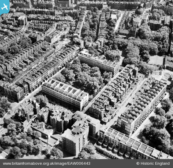
EAW006443 ENGLAND (1947). Ennismore Gardens and surrounding streets, Knightsbridge, 1947
© Hawlfraint cyfranwyr OpenStreetMap a thrwyddedwyd gan yr OpenStreetMap Foundation. 2026. Trwyddedir y gartograffeg fel CC BY-SA.
Delweddau cyfagos (13)
Manylion
| Pennawd | [EAW006443] Ennismore Gardens and surrounding streets, Knightsbridge, 1947 |
| Cyfeirnod | EAW006443 |
| Dyddiad | 2-June-1947 |
| Dolen | |
| Enw lle | KNIGHTSBRIDGE |
| Plwyf | |
| Ardal | |
| Gwlad | ENGLAND |
| Dwyreiniad / Gogleddiad | 527079, 179425 |
| Hydred / Lledred | -0.1690220118109, 51.498976457151 |
| Cyfeirnod Grid Cenedlaethol | TQ271794 |
Pinnau

MB |
Saturday 9th of November 2013 10:46:02 AM | |

MB |
Saturday 9th of November 2013 10:44:01 AM | |

MB |
Saturday 9th of November 2013 10:43:32 AM | |

MB |
Saturday 9th of November 2013 10:40:04 AM | |

MB |
Saturday 9th of November 2013 10:38:48 AM | |

MB |
Saturday 9th of November 2013 10:34:52 AM |


![[EAW006443] Ennismore Gardens and surrounding streets, Knightsbridge, 1947](http://britainfromabove.org.uk/sites/all/libraries/aerofilms-images/public/100x100/EAW/006/EAW006443.jpg)
![[EAW006440] Ennismore Gardens and surrounding streets, Knightsbridge, 1947](http://britainfromabove.org.uk/sites/all/libraries/aerofilms-images/public/100x100/EAW/006/EAW006440.jpg)
![[EAW006445] Ennismore Gardens and surrounding streets, Knightsbridge, 1947](http://britainfromabove.org.uk/sites/all/libraries/aerofilms-images/public/100x100/EAW/006/EAW006445.jpg)
![[EAW006444] Ennismore Gardens and surrounding streets, Knightsbridge, 1947](http://britainfromabove.org.uk/sites/all/libraries/aerofilms-images/public/100x100/EAW/006/EAW006444.jpg)
![[EAW006437] Ennismore Gardens and surrounding streets, Knightsbridge, 1947](http://britainfromabove.org.uk/sites/all/libraries/aerofilms-images/public/100x100/EAW/006/EAW006437.jpg)
![[EAW006439] Ennismore Gardens and surrounding streets, Knightsbridge, 1947](http://britainfromabove.org.uk/sites/all/libraries/aerofilms-images/public/100x100/EAW/006/EAW006439.jpg)
![[EAW006441] Ennismore Gardens and surrounding streets, Knightsbridge, 1947](http://britainfromabove.org.uk/sites/all/libraries/aerofilms-images/public/100x100/EAW/006/EAW006441.jpg)
![[EAW006442] Ennismore Gardens and surrounding streets, Knightsbridge, 1947](http://britainfromabove.org.uk/sites/all/libraries/aerofilms-images/public/100x100/EAW/006/EAW006442.jpg)
![[EAW006438] Ennismore Gardens and surrounding streets, Knightsbridge, 1947](http://britainfromabove.org.uk/sites/all/libraries/aerofilms-images/public/100x100/EAW/006/EAW006438.jpg)
![[EAW000554] Victoria and Albert Museum, Hyde Park and environs, Knightsbridge, 1946](http://britainfromabove.org.uk/sites/all/libraries/aerofilms-images/public/100x100/EAW/000/EAW000554.jpg)
![[EAW000556] Albertopolis, Knightsbridge, 1946](http://britainfromabove.org.uk/sites/all/libraries/aerofilms-images/public/100x100/EAW/000/EAW000556.jpg)
![[EPW010190] The Oratory, Brompton Square and environs, Brompton, 1924. This image has been produced from a print.](http://britainfromabove.org.uk/sites/all/libraries/aerofilms-images/public/100x100/EPW/010/EPW010190.jpg)
![[EAW015858] The Brompton Oratory, Victoria and Albert Museum and surrounding area of Albertopolis, Brompton, 1948](http://britainfromabove.org.uk/sites/all/libraries/aerofilms-images/public/100x100/EAW/015/EAW015858.jpg)