
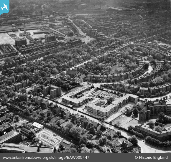
EAW005447 ENGLAND (1947). The Hilldrop Estate under construction, Tufnell Park, 1947
© Hawlfraint cyfranwyr OpenStreetMap a thrwyddedwyd gan yr OpenStreetMap Foundation. 2026. Trwyddedir y gartograffeg fel CC BY-SA.
Delweddau cyfagos (16)
EAW005447

EAW005452

EPW053671

EPW053673
 and environs, Tufnell Park, 1937. This image has been affected by flare.")
EPW053667

EPW053664

EPW053668

EPW053672

EPW053674

EAW005451

EAW005448

EPW053669

EAW005454

EAW005449

EAW005457

EAW005450

Manylion
| Pennawd | [EAW005447] The Hilldrop Estate under construction, Tufnell Park, 1947 |
| Cyfeirnod | EAW005447 |
| Dyddiad | May-1947 |
| Dolen | |
| Enw lle | TUFNELL PARK |
| Plwyf | |
| Ardal | |
| Gwlad | ENGLAND |
| Dwyreiniad / Gogleddiad | 529954, 185302 |
| Hydred / Lledred | -0.12545363863229, 51.551143153804 |
| Cyfeirnod Grid Cenedlaethol | TQ300853 |
Pinnau

billyfern |
Sunday 5th of October 2014 05:39:51 PM | |
|
billyfern |
Sunday 5th of October 2014 05:39:26 PM | |
|
billyfern |
Sunday 5th of October 2014 05:39:24 PM | |
|
Hermann the German |
Thursday 26th of June 2014 03:38:01 PM | |
|
Hermann the German |
Thursday 26th of June 2014 03:26:04 PM |