
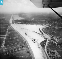
EAW003834 ENGLAND (1947). Flooding of the River Great Ouse near Littleport Railway Station, Littleport, from the north-east, 1947

© Hawlfraint cyfranwyr OpenStreetMap a thrwyddedwyd gan yr OpenStreetMap Foundation. 2026. Trwyddedir y gartograffeg fel CC BY-SA.
Manylion
| Pennawd | [EAW003834] Flooding of the River Great Ouse near Littleport Railway Station, Littleport, from the north-east, 1947 |
| Cyfeirnod | EAW003834 |
| Dyddiad | March-1947 |
| Dolen | |
| Enw lle | LITTLEPORT |
| Plwyf | LITTLEPORT |
| Ardal | |
| Gwlad | ENGLAND |
| Dwyreiniad / Gogleddiad | 557577, 287229 |
| Hydred / Lledred | 0.31957514529846, 52.459868848477 |
| Cyfeirnod Grid Cenedlaethol | TL576872 |
Pinnau

Matt Aldred edob.mattaldred.com |
Wednesday 11th of June 2025 10:25:52 AM | |
|
Matt Aldred edob.mattaldred.com |
Thursday 22nd of May 2025 02:25:04 PM | |
|
Matt Aldred edob.mattaldred.com |
Thursday 22nd of May 2025 02:23:58 PM | |
|
Matt Aldred edob.mattaldred.com |
Thursday 22nd of May 2025 02:22:56 PM | |
|
Matt Aldred edob.mattaldred.com |
Thursday 22nd of May 2025 02:22:39 PM | |
|
Matt Aldred edob.mattaldred.com |
Monday 8th of March 2021 08:29:15 PM | |
|
Matt Aldred edob.mattaldred.com |
Monday 2nd of September 2019 03:15:06 PM | |

cptpies |
Friday 20th of May 2016 09:04:43 AM | |
|
jrussill |
Friday 24th of July 2015 12:20:41 PM |
Cyfraniadau Grŵp
WW2 Pillbox |
jrussill |
Friday 24th of July 2015 12:31:59 PM |