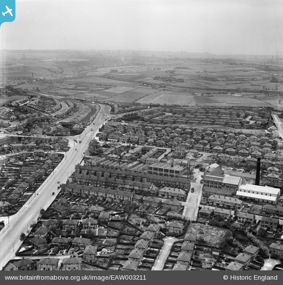
EAW003211 ENGLAND (1946). Dewsbury Road, Grove Hall Mills and environs, Beeston, from the north-east, 1946
© Hawlfraint cyfranwyr OpenStreetMap a thrwyddedwyd gan yr OpenStreetMap Foundation. 2026. Trwyddedir y gartograffeg fel CC BY-SA.
Delweddau cyfagos (17)
Manylion
| Pennawd | [EAW003211] Dewsbury Road, Grove Hall Mills and environs, Beeston, from the north-east, 1946 |
| Cyfeirnod | EAW003211 |
| Dyddiad | 18-October-1946 |
| Dolen | |
| Enw lle | BEESTON |
| Plwyf | |
| Ardal | |
| Gwlad | ENGLAND |
| Dwyreiniad / Gogleddiad | 429025, 430049 |
| Hydred / Lledred | -1.5596295996072, 53.765761596854 |
| Cyfeirnod Grid Cenedlaethol | SE290300 |
Pinnau

redmist |
Monday 15th of November 2021 11:44:48 PM | |

redmist |
Tuesday 15th of October 2019 09:26:44 AM | |

rew |
Saturday 28th of July 2018 05:27:45 PM | |

rew |
Saturday 28th of July 2018 05:26:45 PM | |

rew |
Saturday 28th of July 2018 05:25:00 PM | |

John Wass |
Friday 28th of August 2015 03:08:17 PM |


![[EAW003211] Dewsbury Road, Grove Hall Mills and environs, Beeston, from the north-east, 1946](http://britainfromabove.org.uk/sites/all/libraries/aerofilms-images/public/100x100/EAW/003/EAW003211.jpg)
![[EAW003210] Oakhurst Avenue, Grove Hall Mills and environs, Beeston, from the south-east, 1946](http://britainfromabove.org.uk/sites/all/libraries/aerofilms-images/public/100x100/EAW/003/EAW003210.jpg)
![[EAW002618] The Forgrove Machinery Co Works off Dewsbury Road and the surrounding residential area, Leeds, 1946](http://britainfromabove.org.uk/sites/all/libraries/aerofilms-images/public/100x100/EAW/002/EAW002618.jpg)
![[EAW002620] The Forgrove Machinery Co Works off Dewsbury Road and the surrounding residential area, Leeds, 1946](http://britainfromabove.org.uk/sites/all/libraries/aerofilms-images/public/100x100/EAW/002/EAW002620.jpg)
![[EAW003217] Grove Hall Mills and environs, Beeston, from the south-east, 1946](http://britainfromabove.org.uk/sites/all/libraries/aerofilms-images/public/100x100/EAW/003/EAW003217.jpg)
![[EAW003214] Grove Hall Mills and environs, Beeston, 1946](http://britainfromabove.org.uk/sites/all/libraries/aerofilms-images/public/100x100/EAW/003/EAW003214.jpg)
![[EAW003206] Residential streets surrounding Grove Hall Mills, Beeston, from the north-east, 1946](http://britainfromabove.org.uk/sites/all/libraries/aerofilms-images/public/100x100/EAW/003/EAW003206.jpg)
![[EAW002619] The Forgrove Machinery Co Works off Dewsbury Road and the surrounding residential area, Leeds, 1946](http://britainfromabove.org.uk/sites/all/libraries/aerofilms-images/public/100x100/EAW/002/EAW002619.jpg)
![[EAW003207] Grove Hall Mills and environs, Beeston, from the south-east, 1946](http://britainfromabove.org.uk/sites/all/libraries/aerofilms-images/public/100x100/EAW/003/EAW003207.jpg)
![[EAW003212] Residential streets surrounding Grove Hall Mills, Beeston, from the south-west, 1946](http://britainfromabove.org.uk/sites/all/libraries/aerofilms-images/public/100x100/EAW/003/EAW003212.jpg)
![[EAW003215] Grove Hall Mills and environs, Beeston, 1946](http://britainfromabove.org.uk/sites/all/libraries/aerofilms-images/public/100x100/EAW/003/EAW003215.jpg)
![[EAW003213] Grove Hall Mills and environs, Beeston, 1946](http://britainfromabove.org.uk/sites/all/libraries/aerofilms-images/public/100x100/EAW/003/EAW003213.jpg)
![[EAW003208] Old Lane, Grove Hall Mills and environs, Beeston, from the south-east, 1946](http://britainfromabove.org.uk/sites/all/libraries/aerofilms-images/public/100x100/EAW/003/EAW003208.jpg)
![[EAW002617] The Forgrove Machinery Co Works off Dewsbury Road and the surrounding residential area, Leeds, from the south-east, 1946](http://britainfromabove.org.uk/sites/all/libraries/aerofilms-images/public/100x100/EAW/002/EAW002617.jpg)
![[EAW003218] Grove Hall Mills and environs, Beeston, from the north, 1946](http://britainfromabove.org.uk/sites/all/libraries/aerofilms-images/public/100x100/EAW/003/EAW003218.jpg)
![[EAW003209] Grovehall Drive, Grove Hall Mills and environs, Beeston, from the north, 1946](http://britainfromabove.org.uk/sites/all/libraries/aerofilms-images/public/100x100/EAW/003/EAW003209.jpg)
![[EAW003216] Residential streets surrounding Grove Hall Mills, Beeston, from the north-west, 1946](http://britainfromabove.org.uk/sites/all/libraries/aerofilms-images/public/100x100/EAW/003/EAW003216.jpg)