
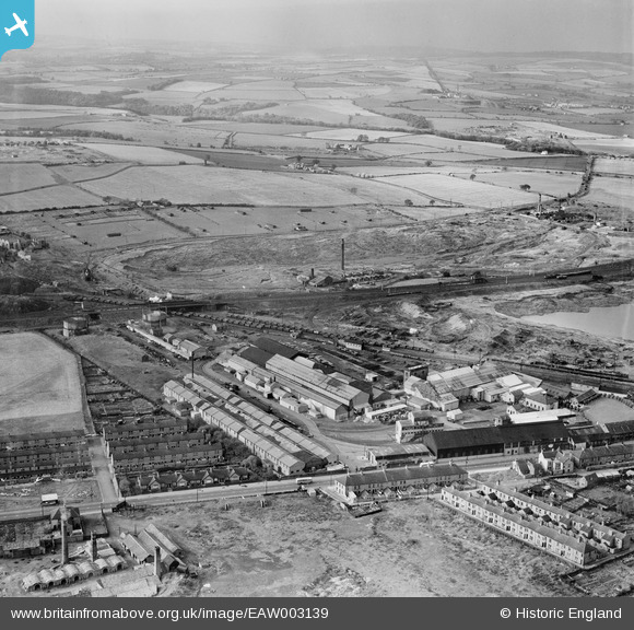
EAW003139 ENGLAND (1946). The Birtley Iron Co Ltd Works and the surrounding area, Birtley, from the east, 1946
© Hawlfraint cyfranwyr OpenStreetMap a thrwyddedwyd gan yr OpenStreetMap Foundation. 2026. Trwyddedir y gartograffeg fel CC BY-SA.
Delweddau cyfagos (13)
EAW003139

EAW003146

EAW003149

EAW003144

EAW003147

EAW003140

EAW003145

EAW003143

EAW003141

EAW003148

EAW003142

EAW003138

EAW003136

Manylion
| Pennawd | [EAW003139] The Birtley Iron Co Ltd Works and the surrounding area, Birtley, from the east, 1946 |
| Cyfeirnod | EAW003139 |
| Dyddiad | 23-October-1946 |
| Dolen | |
| Enw lle | BIRTLEY |
| Plwyf | |
| Ardal | |
| Gwlad | ENGLAND |
| Dwyreiniad / Gogleddiad | 427162, 555088 |
| Hydred / Lledred | -1.5765034631207, 54.889710246716 |
| Cyfeirnod Grid Cenedlaethol | NZ272551 |
Pinnau

Matt Aldred edob.mattaldred.com |
Monday 8th of March 2021 06:37:16 PM | |

Nodrog1826 |
Friday 4th of October 2019 07:41:08 PM | |

Sparky |
Friday 15th of September 2017 09:02:54 AM | |
|
Sparky |
Friday 15th of September 2017 09:02:16 AM | |
|
Stuart |
Tuesday 10th of September 2013 02:50:56 PM |