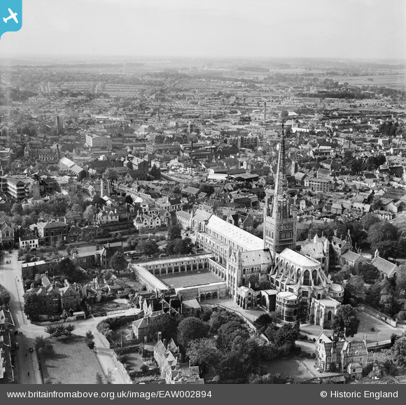
EAW002894 ENGLAND (1946). Norwich Cathedral and the city centre, Norwich, from the east, 1946
© Hawlfraint cyfranwyr OpenStreetMap a thrwyddedwyd gan yr OpenStreetMap Foundation. 2026. Trwyddedir y gartograffeg fel CC BY-SA.
Delweddau cyfagos (31)
Manylion
| Pennawd | [EAW002894] Norwich Cathedral and the city centre, Norwich, from the east, 1946 |
| Cyfeirnod | EAW002894 |
| Dyddiad | 1-October-1946 |
| Dolen | |
| Enw lle | NORWICH |
| Plwyf | |
| Ardal | |
| Gwlad | ENGLAND |
| Dwyreiniad / Gogleddiad | 623501, 308873 |
| Hydred / Lledred | 1.3030753702703, 52.631157214211 |
| Cyfeirnod Grid Cenedlaethol | TG235089 |
Pinnau

Sparky |
Saturday 16th of September 2017 03:06:49 PM | |

peteabove |
Tuesday 20th of January 2015 01:29:14 PM | |

Alan McFaden |
Wednesday 13th of November 2013 09:23:26 PM | |

Alan McFaden |
Wednesday 13th of November 2013 09:22:44 PM |
Cyfraniadau Grŵp
Site of Robert Stevenson Limited Structural Steel Drawing Office until the move to new premises off Sandy Lane (Hall Road area). |

peteabove |
Tuesday 20th of January 2015 01:28:39 PM |


![[EAW002894] Norwich Cathedral and the city centre, Norwich, from the east, 1946](http://britainfromabove.org.uk/sites/all/libraries/aerofilms-images/public/100x100/EAW/002/EAW002894.jpg)
![[EAW036855] The Cathedral of the Holy and Undivided Trinity, Norwich, 1951. This image has been produced from a print.](http://britainfromabove.org.uk/sites/all/libraries/aerofilms-images/public/100x100/EAW/036/EAW036855.jpg)
![[EAW001933] The Cathedral of the Holy and Undivided Trinity, Norwich, 1946](http://britainfromabove.org.uk/sites/all/libraries/aerofilms-images/public/100x100/EAW/001/EAW001933.jpg)
![[EPW006606] The Holy and Undivided Trinity Cathedral and environs, Norwich, 1921](http://britainfromabove.org.uk/sites/all/libraries/aerofilms-images/public/100x100/EPW/006/EPW006606.jpg)
![[EAW008201] The Cathedral of the Holy and Undivided Trinity and environs, Norwich, 1947](http://britainfromabove.org.uk/sites/all/libraries/aerofilms-images/public/100x100/EAW/008/EAW008201.jpg)
![[EPW006607] The Holy and Undivided Trinity Cathedral, Norwich, 1921](http://britainfromabove.org.uk/sites/all/libraries/aerofilms-images/public/100x100/EPW/006/EPW006607.jpg)
![[EAW036841] The Cathedral of the Holy and Undivided Trinity, Norwich, 1951. This image has been produced from a print marked by Aerofilms Ltd for photo editing.](http://britainfromabove.org.uk/sites/all/libraries/aerofilms-images/public/100x100/EAW/036/EAW036841.jpg)
![[EPW039748] Norwich Cathedral and Cloisters, Norwich, 1932](http://britainfromabove.org.uk/sites/all/libraries/aerofilms-images/public/100x100/EPW/039/EPW039748.jpg)
![[EPW021205] Holy Trinity Cathedral, Norwich, 1928](http://britainfromabove.org.uk/sites/all/libraries/aerofilms-images/public/100x100/EPW/021/EPW021205.jpg)
![[EPW021211] Holy Trinity Cathedral, Norwich, 1928](http://britainfromabove.org.uk/sites/all/libraries/aerofilms-images/public/100x100/EPW/021/EPW021211.jpg)
![[EAW005079] The Cathedral of the Holy and Undivided Trinity and environs, Norwich, 1947](http://britainfromabove.org.uk/sites/all/libraries/aerofilms-images/public/100x100/EAW/005/EAW005079.jpg)
![[EPW006608] The Holy and Undivided Trinity Cathedral, Norwich, 1921](http://britainfromabove.org.uk/sites/all/libraries/aerofilms-images/public/100x100/EPW/006/EPW006608.jpg)
![[EAW005078] The Cathedral of the Holy and Undivided Trinity, Norwich, 1947](http://britainfromabove.org.uk/sites/all/libraries/aerofilms-images/public/100x100/EAW/005/EAW005078.jpg)
![[EAW036838] The Cathedral of the Holy and Undivided Trinity, Norwich, 1951. This image has been produced from a print marked by Aerofilms Ltd for photo editing.](http://britainfromabove.org.uk/sites/all/libraries/aerofilms-images/public/100x100/EAW/036/EAW036838.jpg)
![[EAW036852] The Cathedral of the Holy and Undivided Trinity, Norwich, 1951. This image has been produced from a print.](http://britainfromabove.org.uk/sites/all/libraries/aerofilms-images/public/100x100/EAW/036/EAW036852.jpg)
![[EAW001934] The Cathedral of the Holy and Undivided Trinity, Norwich, 1946](http://britainfromabove.org.uk/sites/all/libraries/aerofilms-images/public/100x100/EAW/001/EAW001934.jpg)
![[EPW021220] Norwich Cathedral, Norwich, 1928](http://britainfromabove.org.uk/sites/all/libraries/aerofilms-images/public/100x100/EPW/021/EPW021220.jpg)
![[EAW036854] The Cathedral of the Holy and Undivided Trinity, Norwich, 1951. This image has been produced from a print.](http://britainfromabove.org.uk/sites/all/libraries/aerofilms-images/public/100x100/EAW/036/EAW036854.jpg)
![[EAW001931] The Cathedral of the Holy and Undivided Trinity, Norwich, 1946](http://britainfromabove.org.uk/sites/all/libraries/aerofilms-images/public/100x100/EAW/001/EAW001931.jpg)
![[EAW001932] The Cathedral of the Holy and Undivided Trinity, Norwich, 1946](http://britainfromabove.org.uk/sites/all/libraries/aerofilms-images/public/100x100/EAW/001/EAW001932.jpg)
![[EAW036840] The Cathedral of the Holy and Undivided Trinity, Norwich, 1951. This image has been produced from a print marked by Aerofilms Ltd for photo editing.](http://britainfromabove.org.uk/sites/all/libraries/aerofilms-images/public/100x100/EAW/036/EAW036840.jpg)
![[EAW036839] The Cathedral of the Holy and Undivided Trinity, Norwich, 1951. This image has been produced from a print marked by Aerofilms Ltd for photo editing.](http://britainfromabove.org.uk/sites/all/libraries/aerofilms-images/public/100x100/EAW/036/EAW036839.jpg)
![[EAW036834] The Cathedral's Upper Close and environs, Norwich, 1951. This image has been produced from a print marked by Aerofilms Ltd for photo editing.](http://britainfromabove.org.uk/sites/all/libraries/aerofilms-images/public/100x100/EAW/036/EAW036834.jpg)
![[EPW021218] Holy Trinity Cathedral, Norwich, 1928](http://britainfromabove.org.uk/sites/all/libraries/aerofilms-images/public/100x100/EPW/021/EPW021218.jpg)
![[EAW036850] The Cathedral of the Holy and Undivided Trinity, Norwich, 1951. This image has been produced from a print.](http://britainfromabove.org.uk/sites/all/libraries/aerofilms-images/public/100x100/EAW/036/EAW036850.jpg)
![[EAW036851] The Cathedral of the Holy and Undivided Trinity, Norwich, 1951. This image has been produced from a print.](http://britainfromabove.org.uk/sites/all/libraries/aerofilms-images/public/100x100/EAW/036/EAW036851.jpg)
![[EAW002892] Norwich Cathedral, Norwich, 1946](http://britainfromabove.org.uk/sites/all/libraries/aerofilms-images/public/100x100/EAW/002/EAW002892.jpg)
![[EAW036849] The Cathedral Close and environs, Norwich, 1951. This image has been produced from a print.](http://britainfromabove.org.uk/sites/all/libraries/aerofilms-images/public/100x100/EAW/036/EAW036849.jpg)
![[EAW036837] The Cathedral Close and environs, Norwich, 1951. This image has been produced from a print marked by Aerofilms Ltd for photo editing.](http://britainfromabove.org.uk/sites/all/libraries/aerofilms-images/public/100x100/EAW/036/EAW036837.jpg)
![[EPW001973] The Cathedral of the Holy and Undivided Trinity and the town centre, Norwich, from the south, 1920](http://britainfromabove.org.uk/sites/all/libraries/aerofilms-images/public/100x100/EPW/001/EPW001973.jpg)
![[EAW001952] Bally and Haldinstein Ltd Boot and Shoe Manufactory and environs, Norwich, 1946](http://britainfromabove.org.uk/sites/all/libraries/aerofilms-images/public/100x100/EAW/001/EAW001952.jpg)

