
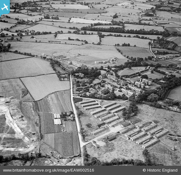
EAW002516 ENGLAND (1946). Baguley Sanatorium and huts of the Emergency Medical Services (EMS) Hospital, Baguley, 1946
© Hawlfraint cyfranwyr OpenStreetMap a thrwyddedwyd gan yr OpenStreetMap Foundation. 2026. Trwyddedir y gartograffeg fel CC BY-SA.
Delweddau cyfagos (6)
EAW002516
 Hospital, Baguley, 1946")
EAW002520

EPW016732

EAW002519

EAW002517

EAW002518

Manylion
| Pennawd | [EAW002516] Baguley Sanatorium and huts of the Emergency Medical Services (EMS) Hospital, Baguley, 1946 |
| Cyfeirnod | EAW002516 |
| Dyddiad | 10-September-1946 |
| Dolen | |
| Enw lle | BAGULEY |
| Plwyf | |
| Ardal | |
| Gwlad | ENGLAND |
| Dwyreiniad / Gogleddiad | 380745, 387854 |
| Hydred / Lledred | -2.2895384288246, 53.386913845576 |
| Cyfeirnod Grid Cenedlaethol | SJ807879 |
Pinnau

denny.53 |
Tuesday 27th of July 2021 04:43:09 PM | |

Chris Bowden |
Tuesday 7th of July 2020 01:59:28 PM | |
|
Chris Bowden |
Tuesday 7th of July 2020 01:56:56 PM | |
|
Chris Bowden |
Tuesday 7th of July 2020 01:54:40 PM | |
|
Chris Bowden |
Tuesday 7th of July 2020 01:53:36 PM | |
|
John Ellis |
Friday 20th of December 2013 06:27:05 PM | |
|
John Ellis |
Friday 20th of December 2013 06:25:49 PM | |
|
John Ellis |
Friday 20th of December 2013 06:24:21 PM | |
|
John Ellis |
Friday 20th of December 2013 06:23:14 PM | |
|
John Ellis |
Friday 20th of December 2013 06:22:31 PM | |
|
John Ellis |
Friday 20th of December 2013 06:19:26 PM | |
|
John Ellis |
Friday 20th of December 2013 06:18:01 PM | |
|
John Ellis |
Friday 20th of December 2013 06:17:04 PM | |
|
John Ellis |
Friday 20th of December 2013 06:14:57 PM | |
|
John Ellis |
Friday 20th of December 2013 06:13:45 PM | |
|
John Ellis |
Friday 20th of December 2013 06:12:17 PM | |
|
John Ellis |
Friday 20th of December 2013 06:10:15 PM | |
|
John Ellis |
Friday 20th of December 2013 06:08:34 PM | |
|
John Ellis |
Friday 20th of December 2013 05:57:40 PM | |
Location Nevendon Drive and Amberley Drive. Mill Brook emerges from under Clay Lane Bridge and has not yet been culverted in this view. Lots of activity in this area and difficult to follow course of Mill Brook especially toward the left hand edge of the photo. After the culvert emerges into a green area and a small brick built bridge (possiblly built to replace the foot bridge at White hour Farm?) Wish I could find a clearer photo or map of this Bridge, possibly still exists near 18 Amberley Drive 2020. original date of build and use unknown? |
Chris Bowden |
Wednesday 17th of June 2020 10:54:41 PM |
|
John Ellis |
Friday 20th of December 2013 05:55:30 PM | |
|
John Ellis |
Friday 20th of December 2013 05:49:50 PM | |
|
John Ellis |
Friday 20th of December 2013 05:47:53 PM | |
|
John Ellis |
Friday 20th of December 2013 05:46:56 PM | |
|
John Ellis |
Friday 20th of December 2013 05:46:04 PM | |
|
John Ellis |
Friday 20th of December 2013 05:44:27 PM | |
|
John Ellis |
Friday 20th of December 2013 05:43:20 PM | |
|
John Ellis |
Friday 20th of December 2013 05:42:30 PM | |
|
John Ellis |
Friday 20th of December 2013 05:40:49 PM | |
|
John Ellis |
Friday 20th of December 2013 05:40:04 PM | |
|
John Ellis |
Friday 20th of December 2013 05:38:40 PM | |
|
John Ellis |
Friday 20th of December 2013 05:37:42 PM | |
|
John Ellis |
Friday 20th of December 2013 05:36:37 PM | |
|
John Ellis |
Friday 20th of December 2013 05:34:01 PM | |
|
John Ellis |
Friday 20th of December 2013 05:31:50 PM | |
|
John Ellis |
Friday 20th of December 2013 05:30:27 PM |