
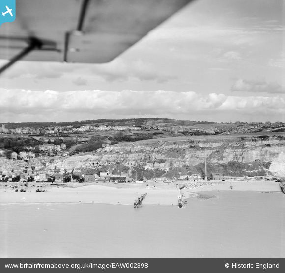
EAW002398 ENGLAND (1946). Rock-A-Nore Road and the cliffs below East Hill, Hastings, from the south, 1946
© Hawlfraint cyfranwyr OpenStreetMap a thrwyddedwyd gan yr OpenStreetMap Foundation. 2026. Trwyddedir y gartograffeg fel CC BY-SA.
Delweddau cyfagos (4)
EAW002398

EPW026187

EAW022979

EAW002397

Manylion
| Pennawd | [EAW002398] Rock-A-Nore Road and the cliffs below East Hill, Hastings, from the south, 1946 |
| Cyfeirnod | EAW002398 |
| Dyddiad | 16-September-1946 |
| Dolen | |
| Enw lle | HASTINGS |
| Plwyf | |
| Ardal | |
| Gwlad | ENGLAND |
| Dwyreiniad / Gogleddiad | 582836, 109541 |
| Hydred / Lledred | 0.59802010156631, 50.85588152482 |
| Cyfeirnod Grid Cenedlaethol | TQ828095 |
Pinnau

redmist |
Tuesday 11th of October 2022 09:37:07 PM | |
|
cptpies |
Thursday 14th of November 2019 01:50:46 PM | |

Sparky |
Sunday 17th of September 2017 11:28:43 PM | |
|
Al |
Monday 2nd of June 2014 04:10:46 PM | |
|
Al |
Monday 2nd of June 2014 04:08:51 PM | |
|
cptpies |
Thursday 28th of November 2013 10:01:21 AM |
Cyfraniadau Grŵp
Rock-a-Nore Road Hastings |

Alan McFaden |
Monday 24th of November 2014 02:26:46 PM |

Anti Tank Blocks, Hastings. |
cptpies |
Thursday 19th of December 2013 03:16:50 PM |