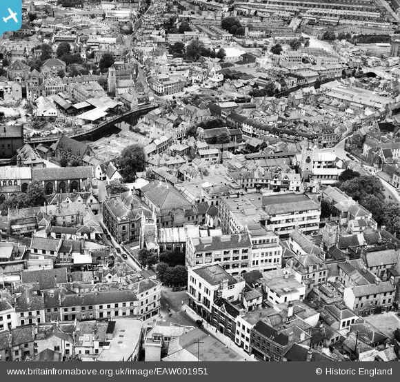
EAW001951 ENGLAND (1946). Bally and Haldinstein Ltd Boot and Shoe Manufactory and environs, Norwich, 1946
© Hawlfraint cyfranwyr OpenStreetMap a thrwyddedwyd gan yr OpenStreetMap Foundation. 2026. Trwyddedir y gartograffeg fel CC BY-SA.
Delweddau cyfagos (18)
Manylion
| Pennawd | [EAW001951] Bally and Haldinstein Ltd Boot and Shoe Manufactory and environs, Norwich, 1946 |
| Cyfeirnod | EAW001951 |
| Dyddiad | 25-July-1946 |
| Dolen | |
| Enw lle | NORWICH |
| Plwyf | |
| Ardal | |
| Gwlad | ENGLAND |
| Dwyreiniad / Gogleddiad | 623235, 308793 |
| Hydred / Lledred | 1.2990972401003, 52.630548592401 |
| Cyfeirnod Grid Cenedlaethol | TG232088 |
Pinnau

Matt Aldred edob.mattaldred.com |
Wednesday 16th of March 2022 08:36:25 PM | |

Matt Aldred edob.mattaldred.com |
Wednesday 16th of March 2022 08:35:21 PM | |

Matt Aldred edob.mattaldred.com |
Wednesday 16th of March 2022 08:33:31 PM | |

redmist |
Tuesday 23rd of November 2021 04:58:16 PM | |

redmist |
Tuesday 23rd of November 2021 04:56:34 PM | |

redmist |
Tuesday 23rd of November 2021 04:54:25 PM | |

redmist |
Tuesday 23rd of November 2021 04:52:53 PM | |

Sparky |
Monday 18th of September 2017 09:54:38 PM | |

Sparky |
Monday 18th of September 2017 09:53:44 PM | |

Sparky |
Monday 18th of September 2017 09:52:43 PM | |

Sparky |
Monday 18th of September 2017 09:46:02 PM | |

Chris Lambert |
Sunday 19th of April 2015 01:51:14 PM | |

Chris Lambert |
Sunday 19th of April 2015 01:48:58 PM | |

Chris Lambert |
Sunday 19th of April 2015 01:46:28 PM | |

Chris Lambert |
Sunday 19th of April 2015 01:45:08 PM | |

Chris Lambert |
Sunday 19th of April 2015 01:44:00 PM | |

Chris Lambert |
Sunday 19th of April 2015 01:42:50 PM | |

Chris Lambert |
Sunday 19th of April 2015 01:42:11 PM | |

Chris Lambert |
Sunday 19th of April 2015 01:41:07 PM | |

Chris Lambert |
Sunday 19th of April 2015 01:38:18 PM | |

Chris Lambert |
Sunday 19th of April 2015 01:37:36 PM | |

Chris Lambert |
Sunday 19th of April 2015 01:36:32 PM | |

Chris Lambert |
Sunday 19th of April 2015 01:35:28 PM | |

Chris Lambert |
Sunday 19th of April 2015 01:34:16 PM | |

Chris Lambert |
Sunday 19th of April 2015 01:33:24 PM | |

Chris Lambert |
Sunday 19th of April 2015 01:31:38 PM | |

peteabove |
Sunday 11th of January 2015 03:56:51 PM | |

peteabove |
Sunday 11th of January 2015 03:46:52 PM |


![[EAW001951] Bally and Haldinstein Ltd Boot and Shoe Manufactory and environs, Norwich, 1946](http://britainfromabove.org.uk/sites/all/libraries/aerofilms-images/public/100x100/EAW/001/EAW001951.jpg)
![[EAW001954] The church of St Michael at Plea and Bally and Haldinstein Ltd Boot and Shoe Manufactory, Norwich, 1946](http://britainfromabove.org.uk/sites/all/libraries/aerofilms-images/public/100x100/EAW/001/EAW001954.jpg)
![[EAW001950] Bally and Haldinstein Ltd Boot and Shoe Manufactory, Norwich, 1946](http://britainfromabove.org.uk/sites/all/libraries/aerofilms-images/public/100x100/EAW/001/EAW001950.jpg)
![[EAW001953] Bally and Haldinstein Ltd Boot and Shoe Manufactory, Norwich, 1946](http://britainfromabove.org.uk/sites/all/libraries/aerofilms-images/public/100x100/EAW/001/EAW001953.jpg)
![[EAW001952] Bally and Haldinstein Ltd Boot and Shoe Manufactory and environs, Norwich, 1946](http://britainfromabove.org.uk/sites/all/libraries/aerofilms-images/public/100x100/EAW/001/EAW001952.jpg)
![[EAW036848] The city centre, Norwich, 1951. This image has been produced from a print.](http://britainfromabove.org.uk/sites/all/libraries/aerofilms-images/public/100x100/EAW/036/EAW036848.jpg)
![[EAW002893] Norwich Castle Museum, Norwich Cathedral and the city centre, Norwich, 1946](http://britainfromabove.org.uk/sites/all/libraries/aerofilms-images/public/100x100/EAW/002/EAW002893.jpg)
![[EAW036851] The Cathedral of the Holy and Undivided Trinity, Norwich, 1951. This image has been produced from a print.](http://britainfromabove.org.uk/sites/all/libraries/aerofilms-images/public/100x100/EAW/036/EAW036851.jpg)
![[EAW036834] The Cathedral's Upper Close and environs, Norwich, 1951. This image has been produced from a print marked by Aerofilms Ltd for photo editing.](http://britainfromabove.org.uk/sites/all/libraries/aerofilms-images/public/100x100/EAW/036/EAW036834.jpg)
![[EAW036840] The Cathedral of the Holy and Undivided Trinity, Norwich, 1951. This image has been produced from a print marked by Aerofilms Ltd for photo editing.](http://britainfromabove.org.uk/sites/all/libraries/aerofilms-images/public/100x100/EAW/036/EAW036840.jpg)
![[EAW036854] The Cathedral of the Holy and Undivided Trinity, Norwich, 1951. This image has been produced from a print.](http://britainfromabove.org.uk/sites/all/libraries/aerofilms-images/public/100x100/EAW/036/EAW036854.jpg)
![[EAW036838] The Cathedral of the Holy and Undivided Trinity, Norwich, 1951. This image has been produced from a print marked by Aerofilms Ltd for photo editing.](http://britainfromabove.org.uk/sites/all/libraries/aerofilms-images/public/100x100/EAW/036/EAW036838.jpg)
![[EAW001934] The Cathedral of the Holy and Undivided Trinity, Norwich, 1946](http://britainfromabove.org.uk/sites/all/libraries/aerofilms-images/public/100x100/EAW/001/EAW001934.jpg)
![[EAW036852] The Cathedral of the Holy and Undivided Trinity, Norwich, 1951. This image has been produced from a print.](http://britainfromabove.org.uk/sites/all/libraries/aerofilms-images/public/100x100/EAW/036/EAW036852.jpg)
![[EAW008141] Norwich Castle and environs, Norwich, 1947. This image was marked by Aerofilms Ltd for photo editing.](http://britainfromabove.org.uk/sites/all/libraries/aerofilms-images/public/100x100/EAW/008/EAW008141.jpg)
![[EAW008201] The Cathedral of the Holy and Undivided Trinity and environs, Norwich, 1947](http://britainfromabove.org.uk/sites/all/libraries/aerofilms-images/public/100x100/EAW/008/EAW008201.jpg)
![[EAW036846] The city centre, Norwich, 1951. This image has been produced from a print.](http://britainfromabove.org.uk/sites/all/libraries/aerofilms-images/public/100x100/EAW/036/EAW036846.jpg)
![[EAW002892] Norwich Cathedral, Norwich, 1946](http://britainfromabove.org.uk/sites/all/libraries/aerofilms-images/public/100x100/EAW/002/EAW002892.jpg)