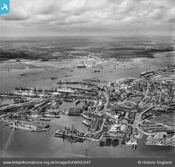
EAW001347 ENGLAND (1946). Inner and Outer Docks and environs, Southampton, from the east, 1946
© Hawlfraint cyfranwyr OpenStreetMap a thrwyddedwyd gan yr OpenStreetMap Foundation. 2026. Trwyddedir y gartograffeg fel CC BY-SA.
Delweddau cyfagos (23)
Manylion
| Pennawd | [EAW001347] Inner and Outer Docks and environs, Southampton, from the east, 1946 |
| Cyfeirnod | EAW001347 |
| Dyddiad | 28-June-1946 |
| Dolen | |
| Enw lle | SOUTHAMPTON |
| Plwyf | |
| Ardal | |
| Gwlad | ENGLAND |
| Dwyreiniad / Gogleddiad | 442187, 110824 |
| Hydred / Lledred | -1.4000809318604, 50.894800803914 |
| Cyfeirnod Grid Cenedlaethol | SU422108 |
Pinnau

Jessie Russel |
Monday 7th of July 2025 10:37:29 PM | |

Jessie Russel |
Monday 7th of July 2025 10:33:47 PM | |

Andy Russel |
Sunday 2nd of August 2020 09:19:16 AM | |

Graham Yaxley |
Monday 5th of January 2015 06:26:48 PM | |

Graham Yaxley |
Monday 5th of January 2015 06:24:59 PM | |

Graham Yaxley |
Monday 5th of January 2015 06:22:32 PM | |

Graham Yaxley |
Monday 5th of January 2015 12:14:39 AM |
Cyfraniadau Grŵp
St. Michael's Church from Bernard Street 01/05/2014 |

Class31 |
Friday 2nd of May 2014 04:08:40 PM |


![[EAW001347] Inner and Outer Docks and environs, Southampton, from the east, 1946](http://britainfromabove.org.uk/sites/all/libraries/aerofilms-images/public/100x100/EAW/001/EAW001347.jpg)
![[EAW008798] Harland & Wolff Ltd Shipbuilding and Engineering Works and the Town Quay, Southampton, 1947](http://britainfromabove.org.uk/sites/all/libraries/aerofilms-images/public/100x100/EAW/008/EAW008798.jpg)
![[EAW008791] Harland & Wolff Ltd Shipbuilding and Engineering Works at Boundary Road West and the docks, Southampton, 1947. This image was marked by Aerofilms Ltd for photo editing.](http://britainfromabove.org.uk/sites/all/libraries/aerofilms-images/public/100x100/EAW/008/EAW008791.jpg)
![[EAW008796] The SS Asturias in Trafalgar Dry Dock and the Harland & Wolff Ltd Shipbuilding and Engineering Works, Southampton, 1947](http://britainfromabove.org.uk/sites/all/libraries/aerofilms-images/public/100x100/EAW/008/EAW008796.jpg)
![[EAW008801] Harland & Wolff Ltd Shipbuilding and Engineering Works, Southampton, 1947](http://britainfromabove.org.uk/sites/all/libraries/aerofilms-images/public/100x100/EAW/008/EAW008801.jpg)
![[EPW041064] Ocean Dock, the RMS Mauretania in the floating dry dock and environs, Southampton, from the north-west, 1933](http://britainfromabove.org.uk/sites/all/libraries/aerofilms-images/public/100x100/EPW/041/EPW041064.jpg)
![[EAW008795] Harland & Wolff Ltd Shipbuilding and Engineering Works, Trafalgar Dry Dock, Ocean Dock and Queen's Park, Southampton, 1947](http://britainfromabove.org.uk/sites/all/libraries/aerofilms-images/public/100x100/EAW/008/EAW008795.jpg)
![[EAW001375] An unidentified ship in Trafalgar Dry Dock, the Inner and Outer Docks and environs, Southampton, 1946](http://britainfromabove.org.uk/sites/all/libraries/aerofilms-images/public/100x100/EAW/001/EAW001375.jpg)
![[EAW008800] Harland & Wolff Ltd Shipbuilding and Engineering Works and the docks, Southampton, 1947](http://britainfromabove.org.uk/sites/all/libraries/aerofilms-images/public/100x100/EAW/008/EAW008800.jpg)
![[EAW008803] Harland & Wolff Ltd Shipbuilding and Engineering Works, Trafalgar Dry Dock, Ocean Dock and Empress Dock, Southampton, 1947](http://britainfromabove.org.uk/sites/all/libraries/aerofilms-images/public/100x100/EAW/008/EAW008803.jpg)
![[EPW032342] The Floating Dock, the Town Quay and Trafalgar Dry Dock, Southampton, 1930](http://britainfromabove.org.uk/sites/all/libraries/aerofilms-images/public/100x100/EPW/032/EPW032342.jpg)
![[EAW008802] Harland & Wolff Ltd Shipbuilding and Engineering Works and the docks, Southampton, from the south-west, 1947](http://britainfromabove.org.uk/sites/all/libraries/aerofilms-images/public/100x100/EAW/008/EAW008802.jpg)
![[EAW189228] Southampton Docks, Southampton, 1968](http://britainfromabove.org.uk/sites/all/libraries/aerofilms-images/public/100x100/EAW/189/EAW189228.jpg)
![[EAW020646] The British Overseas Airways Corporation (BOAC) Marine Airport and the surrounding docks, Southampton, 1948](http://britainfromabove.org.uk/sites/all/libraries/aerofilms-images/public/100x100/EAW/020/EAW020646.jpg)
![[EAW020645] The British Overseas Airways Corporation (BOAC) Marine Airport and the surrounding docks, Southampton, 1948](http://britainfromabove.org.uk/sites/all/libraries/aerofilms-images/public/100x100/EAW/020/EAW020645.jpg)
![[EAW020647] The British Overseas Airways Corporation (BOAC) Marine Airport and the surrounding docks, Southampton, 1948](http://britainfromabove.org.uk/sites/all/libraries/aerofilms-images/public/100x100/EAW/020/EAW020647.jpg)
![[EPW041065] Ocean Dock, the RMS Mauretania in the floating dry dock and environs, Southampton, from the north-west, 1933](http://britainfromabove.org.uk/sites/all/libraries/aerofilms-images/public/100x100/EPW/041/EPW041065.jpg)
![[EAW001374] The Grey Ghost (RMS Queen Mary) in Ocean Dock, Southampton, 1946](http://britainfromabove.org.uk/sites/all/libraries/aerofilms-images/public/100x100/EAW/001/EAW001374.jpg)
![[EPW020455] The Docks, Floating Dock and RMS Berengaria, Southampton, 1928](http://britainfromabove.org.uk/sites/all/libraries/aerofilms-images/public/100x100/EPW/020/EPW020455.jpg)
![[EAW001358] The Docks, Southampton, 1946](http://britainfromabove.org.uk/sites/all/libraries/aerofilms-images/public/100x100/EAW/001/EAW001358.jpg)
![[EPW009077] The Inner Dock and Queen's Park area, Southampton, 1923](http://britainfromabove.org.uk/sites/all/libraries/aerofilms-images/public/100x100/EPW/009/EPW009077.jpg)
![[EPW020452] Floating Dock, Southampton, 1928](http://britainfromabove.org.uk/sites/all/libraries/aerofilms-images/public/100x100/EPW/020/EPW020452.jpg)
![[EPW042962] High Street and environs, Southampton, from the south, 1933](http://britainfromabove.org.uk/sites/all/libraries/aerofilms-images/public/100x100/EPW/042/EPW042962.jpg)