
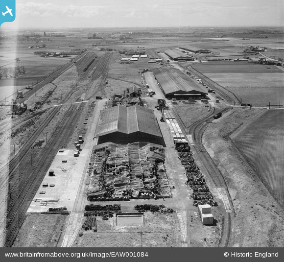
EAW001084 ENGLAND (1946). The fire-damaged Kirkby Inland Storage Depot of the Mersey Docks and Harbour Board, Bickerstaffe, from the north-east, 1946
© Hawlfraint cyfranwyr OpenStreetMap a thrwyddedwyd gan yr OpenStreetMap Foundation. 2026. Trwyddedir y gartograffeg fel CC BY-SA.
Delweddau cyfagos (2)
EAW001084

EAW001086

Manylion
| Pennawd | [EAW001084] The fire-damaged Kirkby Inland Storage Depot of the Mersey Docks and Harbour Board, Bickerstaffe, from the north-east, 1946 |
| Cyfeirnod | EAW001084 |
| Dyddiad | 3-June-1946 |
| Dolen | |
| Enw lle | BICKERSTAFFE |
| Plwyf | SIMONSWOOD |
| Ardal | |
| Gwlad | ENGLAND |
| Dwyreiniad / Gogleddiad | 343596, 400850 |
| Hydred / Lledred | -2.850434563591, 53.501067983147 |
| Cyfeirnod Grid Cenedlaethol | SD436009 |
Pinnau

austin |
Friday 1st of March 2024 06:55:37 PM | |
|
austin |
Sunday 2nd of July 2023 07:59:58 PM | |
|
austin |
Tuesday 18th of April 2023 06:33:46 PM | |
|
austin |
Friday 10th of March 2023 03:26:36 PM | |
|
austin |
Wednesday 7th of April 2021 08:40:37 PM | |
|
Pentaprism |
Monday 9th of November 2020 09:59:11 PM | |
|
austin |
Thursday 17th of September 2020 10:12:13 AM | |
|
Skier |
Monday 20th of July 2020 03:43:29 PM | |
|
Martynj |
Friday 13th of May 2016 03:28:04 AM | |

Maurice |
Tuesday 17th of September 2013 08:48:06 AM | |
|
Maurice |
Tuesday 17th of September 2013 08:45:39 AM | |
|
Maurice |
Tuesday 17th of September 2013 08:43:15 AM | |
|
Maurice |
Tuesday 17th of September 2013 08:13:12 AM | |
|
Maurice |
Tuesday 17th of September 2013 08:13:07 AM | |
|
Maurice |
Tuesday 17th of September 2013 07:57:01 AM | |
|
Maurice |
Tuesday 17th of September 2013 07:04:48 AM | |
|
Maurice |
Tuesday 17th of September 2013 07:00:49 AM | |
|
Maurice |
Tuesday 17th of September 2013 06:52:44 AM | |
|
Maurice |
Tuesday 17th of September 2013 06:46:17 AM | |
|
Maurice |
Tuesday 17th of September 2013 06:45:48 AM | |
|
Maurice |
Tuesday 17th of September 2013 06:35:20 AM | |
Infact the GC had adopted this style of through yard for some of their later yards e.g. Wath, Grimsby and Mottram. Toton as upgraded by the Midland had through "balloon loops" for sorting and receiving traffic. |

bescotbeast |
Sunday 22nd of September 2013 12:26:04 PM |
|
Maurice |
Tuesday 17th of September 2013 06:27:40 AM | |
|
Maurice |
Tuesday 17th of September 2013 06:22:01 AM | |
|
Maurice |
Tuesday 17th of September 2013 06:20:34 AM | |
|
bescotbeast |
Tuesday 17th of September 2013 03:42:26 AM | |
|
bescotbeast |
Tuesday 17th of September 2013 03:40:23 AM | |
|
bescotbeast |
Tuesday 17th of September 2013 03:27:58 AM | |
|
MB |
Monday 16th of September 2013 11:52:14 PM | |
|
MB |
Monday 16th of September 2013 11:50:53 PM |

Cyfraniadau Grŵp
Thank you for your help with this picture - the caption will be updated to reflect the identification of the building. Best wishes Laura Maddison (Britain from Above Cataloguer) |

Laura Maddison |
Wednesday 21st of May 2014 09:59:22 AM |
General Comments: - Firstly this is recorded on the 1955 OS map as 'Kirkby Inland Sorting Depot'. It is mostly still intact at that date and the outline of the burnt out buildings seems to suggest they may have been rebuilt. By 1955 the number of railway tracks is somewhat reduced. Secondly, why was it there? Answer One - The 'Inland' part of the title suggests it was related to the Port of Liverpool, this being a safer and more spacious place to sort and store material that had arrived on the Atlantic convoys. Many of the conveys arrived in Liverpool, it being considered a safer approach than the English Channel. Much of the war materials would than be forwarded to southern England in preparation for D day and despatch from Southampton to France. Answer Two - Just out of this picture to the left is the Royal Ordnance Factory (ROF) No.7 Kirkby 1940-46 that employed 20,000 people. Clearly such an operation would have generated a large amount of the railway traffic and the ROF is connected to the sorting sidings, seen here, by one side of a triangular junction. Between this site and the water tower to the rear of this picture, and next to the wood called the Old Rough, the map shows an 'Industrial Hostel'. This was for the women workers in the ROF. These extra details can be seen on 'Old Maps' (http://www.old-maps.co.uk/maps.html), Kirkby or at coordinates 342070, 400170 - 1955-56. |
Maurice |
Sunday 22nd of September 2013 01:15:29 PM |
In answer to your answer one I'd already commented on the role of this location at 03:45 and put a newspaper clipping found via Google within my comment regarding the fire in 1946. |
bescotbeast |
Sunday 22nd of September 2013 01:15:29 PM |
One of the references I searched on this one stated that nearby Bickerstaffe was a centre for Quakerism in earlier times. One wonders what these peaceful souls would have made of all this activity in support of war? |
Maurice |
Tuesday 17th of September 2013 08:50:54 AM |
http://news.google.com/newspapers?nid=2507&dat=19460415&id=PkxAAAAAIBAJ&sjid=r4wMAAAAIBAJ&pg=3091,5721224 Kirkby Inland sorting depot, warehouses used by the Mersey Docks and Harbours board for storage. This would have been used to enable cargo from ships to be stored safely away from the bombing of the docks. |
bescotbeast |
Tuesday 17th of September 2013 03:45:01 AM |
A World War II government supply depot, judging by the extensive site. It may be associated with a nearby Royal Ordnance factory and ammunition bunkers at Rainford |
MB |
Monday 16th of September 2013 11:54:26 PM |