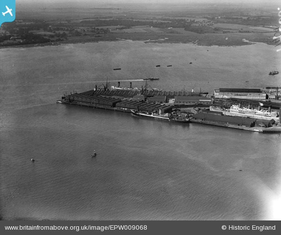
EPW009068 ENGLAND (1923). The Prince of Wales Dry Dock, Southampton, 1923
© Copyright OpenStreetMap contributors and licensed by the OpenStreetMap Foundation. 2024. Cartography is licensed as CC BY-SA.
Nearby Images (20)
Details
| Title | [EPW009068] The Prince of Wales Dry Dock, Southampton, 1923 |
| Reference | EPW009068 |
| Date | 1923 |
| Link | |
| Place name | SOUTHAMPTON |
| Parish | |
| District | |
| Country | ENGLAND |
| Easting / Northing | 442770, 109655 |
| Longitude / Latitude | -1.3919277830029, 50.884245162284 |
| National Grid Reference | SU428097 |
Pins
 Isleworth1961 |
Saturday 25th of May 2013 12:46:23 AM | |
Now identified from other photos at same time as being RMS Windsor Castle. |
 Isleworth1961 |
Sunday 23rd of June 2013 03:23:02 PM |
User Comment Contributions
Also known as No.5 Dry Dock |
 Sailor Steve |
Sunday 11th of August 2013 09:20:43 PM |


![[EPW009068] The Prince of Wales Dry Dock, Southampton, 1923](http://britainfromabove.org.uk/sites/all/libraries/aerofilms-images/public/100x100/EPW/009/EPW009068.jpg)
![[EAW033431] The Cruise Liner Terminal, Southampton, 1950. This image has been produced from a print.](http://britainfromabove.org.uk/sites/all/libraries/aerofilms-images/public/100x100/EAW/033/EAW033431.jpg)
![[EAW033409] Cargo and passenger sheds at the Docks, Southampton, 1950](http://britainfromabove.org.uk/sites/all/libraries/aerofilms-images/public/100x100/EAW/033/EAW033409.jpg)
![[EAW033430] The Cruise Liner Terminal, Southampton, 1950. This image has been produced from a print.](http://britainfromabove.org.uk/sites/all/libraries/aerofilms-images/public/100x100/EAW/033/EAW033430.jpg)
![[EAW035242] The docks and the city, Southampton, from the south, 1951](http://britainfromabove.org.uk/sites/all/libraries/aerofilms-images/public/100x100/EAW/035/EAW035242.jpg)
![[EAW051595] Southampton Docks and the River Test, Southampton, from the south-east, 1953](http://britainfromabove.org.uk/sites/all/libraries/aerofilms-images/public/100x100/EAW/051/EAW051595.jpg)
![[EAW051596] Southampton Docks, Southampton, from the south, 1953](http://britainfromabove.org.uk/sites/all/libraries/aerofilms-images/public/100x100/EAW/051/EAW051596.jpg)
![[EPW020456] The Docks and an unidentified ocean liner, Southampton, 1928](http://britainfromabove.org.uk/sites/all/libraries/aerofilms-images/public/100x100/EPW/020/EPW020456.jpg)
![[EPW041071] The docks, Southampton, from the south, 1933](http://britainfromabove.org.uk/sites/all/libraries/aerofilms-images/public/100x100/EPW/041/EPW041071.jpg)
![[EAW033408] The Docks, Southampton, from the south, 1950](http://britainfromabove.org.uk/sites/all/libraries/aerofilms-images/public/100x100/EAW/033/EAW033408.jpg)
![[EPW039726] The Docks, Southampton, from the south, 1932](http://britainfromabove.org.uk/sites/all/libraries/aerofilms-images/public/100x100/EPW/039/EPW039726.jpg)
![[EPW009067] The Docks and environs, Southampton, from the south-east, 1923](http://britainfromabove.org.uk/sites/all/libraries/aerofilms-images/public/100x100/EPW/009/EPW009067.jpg)
![[EPW009064] The Empress Dock, Prince of Wales Dry Dock and Ocean Dock and envrions, Southampton, 1923](http://britainfromabove.org.uk/sites/all/libraries/aerofilms-images/public/100x100/EPW/009/EPW009064.jpg)
![[EAW033432] The Docks and Cruise Liner Terminal, Southampton, 1950. This image has been produced from a print.](http://britainfromabove.org.uk/sites/all/libraries/aerofilms-images/public/100x100/EAW/033/EAW033432.jpg)
![[EPW009066] The Docks and environs, Southampton, from the east, 1923](http://britainfromabove.org.uk/sites/all/libraries/aerofilms-images/public/100x100/EPW/009/EPW009066.jpg)
![[EAW033414] The Docks, Southampton, from the south-east, 1950](http://britainfromabove.org.uk/sites/all/libraries/aerofilms-images/public/100x100/EAW/033/EAW033414.jpg)
![[EPW039724] The Docks, Southampton, from the south, 1932](http://britainfromabove.org.uk/sites/all/libraries/aerofilms-images/public/100x100/EPW/039/EPW039724.jpg)
![[EPW037411] Ocean liners at the entrance to the Empress Dock and the Prince of Wales Dry Dock, Southampton, 1932. This image has been affected by flare.](http://britainfromabove.org.uk/sites/all/libraries/aerofilms-images/public/100x100/EPW/037/EPW037411.jpg)
![[EPW037412] Ocean liners in the Empress Dock, the Ocean Dock and the Floating Dock, Southampton, 1932. This image has been produced from a damaged negative.](http://britainfromabove.org.uk/sites/all/libraries/aerofilms-images/public/100x100/EPW/037/EPW037412.jpg)
![[EAW008807] The docks, Southampton, from the south, 1947](http://britainfromabove.org.uk/sites/all/libraries/aerofilms-images/public/100x100/EAW/008/EAW008807.jpg)