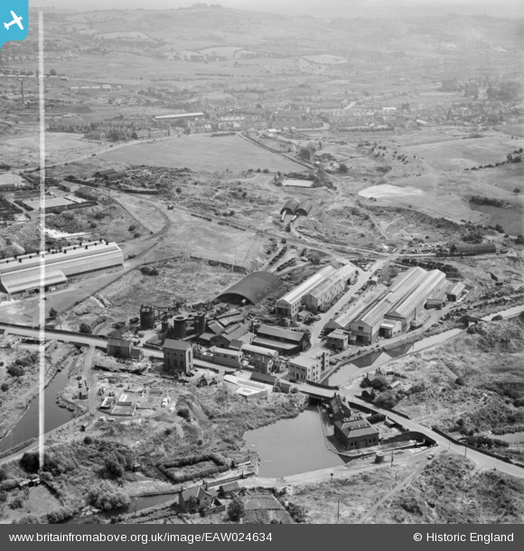
eaw024634 ENGLAND (1949). M & W Grazebrook Ltd Works on Peartree Lane, Netherton, from the west, 1949. This image was marked by Aerofilms Ltd for photo editing.
© Copyright OpenStreetMap contributors and licensed by the OpenStreetMap Foundation. 2025. Cartography is licensed as CC BY-SA.
Nearby Images (24)
Details
| Title | [EAW024634] M & W Grazebrook Ltd Works on Peartree Lane, Netherton, from the west, 1949. This image was marked by Aerofilms Ltd for photo editing. |
| Reference | EAW024634 |
| Date | 12-July-1949 |
| Link | |
| Place name | NETHERTON |
| Parish | |
| District | |
| Country | ENGLAND |
| Easting / Northing | 393487, 288851 |
| Longitude / Latitude | -2.0959474514029, 52.497158788671 |
| National Grid Reference | SO935889 |
Pins
 Steve |
Wednesday 3rd of October 2018 11:50:46 AM |


![[EAW024634] M & W Grazebrook Ltd Works on Peartree Lane, Netherton, from the west, 1949. This image was marked by Aerofilms Ltd for photo editing.](http://britainfromabove.org.uk/sites/all/libraries/aerofilms-images/public/100x100/EAW/024/EAW024634.jpg)
![[EAW024635] M & W Grazebrook Ltd Works on Peartree Lane, Netherton, from the north-west, 1949. This image was marked by Aerofilms Ltd for photo editing.](http://britainfromabove.org.uk/sites/all/libraries/aerofilms-images/public/100x100/EAW/024/EAW024635.jpg)
![[EAW024638] M & W Grazebrook Ltd Works on Peartree Lane and environs, Netherton, from the west, 1949. This image was marked by Aerofilms Ltd for photo editing.](http://britainfromabove.org.uk/sites/all/libraries/aerofilms-images/public/100x100/EAW/024/EAW024638.jpg)
![[EPW046057] The Netherton Iron Works and environs, Netherton, 1934](http://britainfromabove.org.uk/sites/all/libraries/aerofilms-images/public/100x100/EPW/046/EPW046057.jpg)
![[EAW000683] The Netherton Iron Works and the Parkhead Viaduct, Netherton, 1946. This image has been produced from a damaged negative.](http://britainfromabove.org.uk/sites/all/libraries/aerofilms-images/public/100x100/EAW/000/EAW000683.jpg)
![[EPW046055] The Parkhead Viaduct, Netherton Iron Works and environs, Netherton, 1934](http://britainfromabove.org.uk/sites/all/libraries/aerofilms-images/public/100x100/EPW/046/EPW046055.jpg)
![[EAW024639] M & W Grazebrook Ltd Works on Peartree Lane and environs, Netherton, from the north-west, 1949. This image was marked by Aerofilms Ltd for photo editing.](http://britainfromabove.org.uk/sites/all/libraries/aerofilms-images/public/100x100/EAW/024/EAW024639.jpg)
![[EPW046056] The Parkhead Viaduct, Netherton Iron Works and environs, Netherton, 1934](http://britainfromabove.org.uk/sites/all/libraries/aerofilms-images/public/100x100/EPW/046/EPW046056.jpg)
![[EAW024640] M & W Grazebrook Ltd Works on Peartree Lane and environs, Netherton, from the north-west, 1949](http://britainfromabove.org.uk/sites/all/libraries/aerofilms-images/public/100x100/EAW/024/EAW024640.jpg)
![[EAW000686] The Netherton Iron Works and the surrounding area, Netherton, 1946. This image has been produced from a damaged negative.](http://britainfromabove.org.uk/sites/all/libraries/aerofilms-images/public/100x100/EAW/000/EAW000686.jpg)
![[EAW024633] Works along Peartree Lane looking towards Dudley, Netherton, from the south-west, 1949. This image was marked by Aerofilms Ltd for photo editing.](http://britainfromabove.org.uk/sites/all/libraries/aerofilms-images/public/100x100/EAW/024/EAW024633.jpg)
![[EAW024637] Works along Peartree Lane and environs, Netherton, from the south-west, 1949. This image was marked by Aerofilms Ltd for photo editing.](http://britainfromabove.org.uk/sites/all/libraries/aerofilms-images/public/100x100/EAW/024/EAW024637.jpg)
![[EPW046058] The Netherton Iron Works and environs, Netherton, 1934](http://britainfromabove.org.uk/sites/all/libraries/aerofilms-images/public/100x100/EPW/046/EPW046058.jpg)
![[EPW046061] The Netherton Iron Works and environs, Netherton, 1934](http://britainfromabove.org.uk/sites/all/libraries/aerofilms-images/public/100x100/EPW/046/EPW046061.jpg)
![[EPW046060] The Parkhead Viaduct, Netherton Iron Works and environs, Netherton, 1934](http://britainfromabove.org.uk/sites/all/libraries/aerofilms-images/public/100x100/EPW/046/EPW046060.jpg)
![[EPW046059] The Parkhead Viaduct, Netherton Iron Works and environs, Netherton, 1934](http://britainfromabove.org.uk/sites/all/libraries/aerofilms-images/public/100x100/EPW/046/EPW046059.jpg)
![[EAW024636] Works along Peartree Lane and environs, Netherton, from the south, 1949. This image was marked by Aerofilms Ltd for photo editing.](http://britainfromabove.org.uk/sites/all/libraries/aerofilms-images/public/100x100/EAW/024/EAW024636.jpg)
![[EAW000682] The Netherton Iron Works, the Parkhead Viaduct and the surrounding area, Netherton, from the south-east, 1946. This image has been produced from a damaged negative.](http://britainfromabove.org.uk/sites/all/libraries/aerofilms-images/public/100x100/EAW/000/EAW000682.jpg)
![[EAW000684] The Netherton Iron Works, the Parkhead Viaduct and the Thornleigh Brick Works, Netherton, from the south-east, 1946. This image has been produced from a damaged negative.](http://britainfromabove.org.uk/sites/all/libraries/aerofilms-images/public/100x100/EAW/000/EAW000684.jpg)
![[EAW000685] The Netherton Iron Works and the surrounding area, Netherton, 1946. This image has been produced from a damaged negative.](http://britainfromabove.org.uk/sites/all/libraries/aerofilms-images/public/100x100/EAW/000/EAW000685.jpg)
![[EAW027698] John Thompson Ltd Windmill Engineering Works and environs, Dudley, 1949. This image has been produced from a print marked by Aerofilms Ltd for photo editing.](http://britainfromabove.org.uk/sites/all/libraries/aerofilms-images/public/100x100/EAW/027/EAW027698.jpg)
![[EAW041760] The John Thompson (Dudley) Ltd Windmill Engineering Works, Dudley, 1952. This image has been produced from a damaged negative.](http://britainfromabove.org.uk/sites/all/libraries/aerofilms-images/public/100x100/EAW/041/EAW041760.jpg)
![[EAW041766] The John Thompson (Dudley) Ltd Windmill Engineering Works, Dudley, 1952. This image has been produced from a damaged negative.](http://britainfromabove.org.uk/sites/all/libraries/aerofilms-images/public/100x100/EAW/041/EAW041766.jpg)
![[EAW041767] The John Thompson (Dudley) Ltd Windmill Engineering Works, Dudley, 1952. This image has been produced from a damaged negative.](http://britainfromabove.org.uk/sites/all/libraries/aerofilms-images/public/100x100/EAW/041/EAW041767.jpg)