
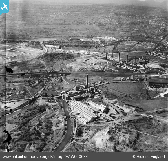
EAW000684 ENGLAND (1946). The Netherton Iron Works, the Parkhead Viaduct and the Thornleigh Brick Works, Netherton, from the south-east, 1946. This image has been produced from a damaged negative.
© Copyright OpenStreetMap contributors and licensed by the OpenStreetMap Foundation. 2026. Cartography is licensed as CC BY-SA.
Nearby Images (24)
EAW000684

EAW000682

EAW024636

EAW024633

EPW046056

EPW046059

EPW046060

EAW024637

EAW000683

EPW046057

EPW046055

EAW000686

EAW024638

EPW046058

EAW024634

EAW000685

EAW024635

EPW046061

EAW024640

EAW024641

EAW024639

EAW027691

EAW027696

EAW027697

Details
| Title | [EAW000684] The Netherton Iron Works, the Parkhead Viaduct and the Thornleigh Brick Works, Netherton, from the south-east, 1946. This image has been produced from a damaged negative. |
| Reference | EAW000684 |
| Date | 10-May-1946 |
| Link | |
| Place name | NETHERTON |
| Parish | |
| District | |
| Country | ENGLAND |
| Easting / Northing | 393584, 288751 |
| Longitude / Latitude | -2.0945165523791, 52.496260841664 |
| National Grid Reference | SO936888 |
Pins

The Circles |
Friday 30th of May 2014 11:21:27 PM | |
|
The Circles |
Friday 30th of May 2014 11:20:02 PM | |
|
Martin |
Thursday 26th of December 2013 12:02:34 PM | |
|
Martin |
Thursday 26th of December 2013 12:00:47 PM | |
|
Martin |
Thursday 26th of December 2013 11:55:59 AM | |
I believe that canal boats [narrow boats] were built [timber] and repaired here at one time. |
The Circles |
Saturday 31st of May 2014 04:09:40 PM |