
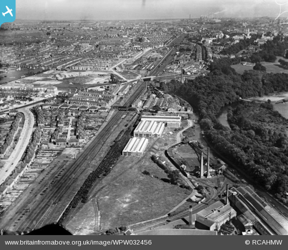
WPW032456 WALES (1930). View of Hall, Lewis & Co., Maindy, oblique aerial view. 5"x4" black and white glass plate negative.
© Copyright OpenStreetMap contributors and licensed by the OpenStreetMap Foundation. 2026. Cartography is licensed as CC BY-SA.
Nearby Images (19)
WAW015086

WAW015087

WAW015088

WAW015089

WAW015090

WAW015091

WAW015092

WAW015093

WAW049112

WAW049113

WAW049114

WAW049115

WAW049116

WAW049117

WAW049118

WAW049119

WAW049120

WPW032453

WPW032456

Details
| Title | [WPW032456] View of Hall, Lewis & Co., Maindy, oblique aerial view. 5"x4" black and white glass plate negative. |
| Reference | WPW032456 |
| Date | 1930 |
| Link | Coflein Archive Item 6370772 |
| Place name | |
| Parish | |
| District | |
| Country | WALES |
| Easting / Northing | 317120, 178240 |
| Longitude / Latitude | -3.1940605294191, 51.496534277583 |
| National Grid Reference | ST171782 |
Pins

Chelsea61 |
Sunday 11th of June 2017 06:34:43 PM | |
|
ERICA |
Monday 5th of June 2017 02:31:11 PM | |
|
me1onhead |
Friday 23rd of August 2013 03:00:00 PM | |
|
Printman |
Saturday 2nd of February 2013 04:26:40 PM | |
|
HPSauce |
Friday 29th of June 2012 10:05:52 PM | |
|
HPSauce |
Friday 29th of June 2012 10:05:16 PM | |
|
HPSauce |
Friday 29th of June 2012 10:03:15 PM | |
|
HPSauce |
Friday 29th of June 2012 10:00:35 PM | |
|
HPSauce |
Friday 29th of June 2012 09:54:36 PM |