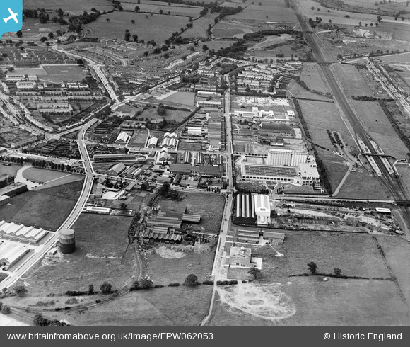
EPW062053 ENGLAND (1939). Broadwater Road and environs, Welwyn Garden City, 1939
© Copyright OpenStreetMap contributors and licensed by the OpenStreetMap Foundation. 2026. Cartography is licensed as CC BY-SA.
Nearby Images (30)
Details
| Title | [EPW062053] Broadwater Road and environs, Welwyn Garden City, 1939 |
| Reference | EPW062053 |
| Date | 28-June-1939 |
| Link | |
| Place name | WELWYN GARDEN CITY |
| Parish | |
| District | |
| Country | ENGLAND |
| Easting / Northing | 524315, 212898 |
| Longitude / Latitude | -0.19692474846347, 51.800441495134 |
| National Grid Reference | TL243129 |
Pins
Be the first to add a comment to this image!


![[EPW062053] Broadwater Road and environs, Welwyn Garden City, 1939](http://britainfromabove.org.uk/sites/all/libraries/aerofilms-images/public/100x100/EPW/062/EPW062053.jpg)
![[EPW054519] The Shredded Wheat Cereal Manufactory, the Murphy Radio Ltd Manufactory and the Norton Grinding Wheel Co Manufactory, Welwyn Garden City, 1937. This image has been affected by flare.](http://britainfromabove.org.uk/sites/all/libraries/aerofilms-images/public/100x100/EPW/054/EPW054519.jpg)
![[EPW022032] Shredded Wheat Factory and Sectional Factories, Welwyn Garden City, 1928](http://britainfromabove.org.uk/sites/all/libraries/aerofilms-images/public/100x100/EPW/022/EPW022032.jpg)
![[EPW054500] The Murphy Radio Ltd Manufactory, the Sectional Factory Units and the Norton Grinding Wheel Co Manufactory, Welwyn Garden City, 1937](http://britainfromabove.org.uk/sites/all/libraries/aerofilms-images/public/100x100/EPW/054/EPW054500.jpg)
![[EPW054511] The Industrial Area, Welwyn Garden City, 1937](http://britainfromabove.org.uk/sites/all/libraries/aerofilms-images/public/100x100/EPW/054/EPW054511.jpg)
![[EPW047354] The Shredded Wheat Factory and other industrial works, Welwyn Garden City, 1935](http://britainfromabove.org.uk/sites/all/libraries/aerofilms-images/public/100x100/EPW/047/EPW047354.jpg)
![[EPW047352] The Shredded Wheat Factory and other industrial works near Broadwater Road, Welwyn Garden City, 1935](http://britainfromabove.org.uk/sites/all/libraries/aerofilms-images/public/100x100/EPW/047/EPW047352.jpg)
![[EPW014807] The Shredded Wheat Factory, Welwyn Garden City, 1926](http://britainfromabove.org.uk/sites/all/libraries/aerofilms-images/public/100x100/EPW/014/EPW014807.jpg)
![[EAW053109] The Shredded Wheat Factory, Welwyn Garden City, 1954](http://britainfromabove.org.uk/sites/all/libraries/aerofilms-images/public/100x100/EAW/053/EAW053109.jpg)
![[EPW014808] The Shredded Wheat Factory, Welwyn Garden City, 1926](http://britainfromabove.org.uk/sites/all/libraries/aerofilms-images/public/100x100/EPW/014/EPW014808.jpg)
![[EPW014809] The Shredded Wheat Factory, Welwyn Garden City, 1926](http://britainfromabove.org.uk/sites/all/libraries/aerofilms-images/public/100x100/EPW/014/EPW014809.jpg)
![[EPW054525] The Railway Station, the Shredded Wheat Cereal Manufactory and the surrounding industrial area, Welwyn Garden City, 1937](http://britainfromabove.org.uk/sites/all/libraries/aerofilms-images/public/100x100/EPW/054/EPW054525.jpg)
![[EPW054507] The Shredded Wheat Cereal Manufactory, Welwyn Garden City, 1937](http://britainfromabove.org.uk/sites/all/libraries/aerofilms-images/public/100x100/EPW/054/EPW054507.jpg)
![[EPW054515] The Welwyn Film Studios and the surrounding industrial area, Welwyn Garden City, 1937](http://britainfromabove.org.uk/sites/all/libraries/aerofilms-images/public/100x100/EPW/054/EPW054515.jpg)
![[EAW053104] The Shredded Wheat Factory, Welwyn Garden City, 1954](http://britainfromabove.org.uk/sites/all/libraries/aerofilms-images/public/100x100/EAW/053/EAW053104.jpg)
![[EPW022022] Archibald D Dawnay & Sons Ltd Constructional Engineering Works, Welwyn Garden City, 1928](http://britainfromabove.org.uk/sites/all/libraries/aerofilms-images/public/100x100/EPW/022/EPW022022.jpg)
![[EAW053083] The Shredded Wheat Factory, Welwyn Garden City, 1954](http://britainfromabove.org.uk/sites/all/libraries/aerofilms-images/public/100x100/EAW/053/EAW053083.jpg)
![[EPW025533] The Shredded Wheat factory, Welwyn Garden City, 1928](http://britainfromabove.org.uk/sites/all/libraries/aerofilms-images/public/100x100/EPW/025/EPW025533.jpg)
![[EPW054516] The Dawnays Limited Engineering Works and surrounding industrial units, Welwyn Garden City, 1937](http://britainfromabove.org.uk/sites/all/libraries/aerofilms-images/public/100x100/EPW/054/EPW054516.jpg)
![[EPW054517] The Dawnays Limited Engineering Works and surrounding industrial units, Welwyn Garden City, 1937](http://britainfromabove.org.uk/sites/all/libraries/aerofilms-images/public/100x100/EPW/054/EPW054517.jpg)
![[EPW054536] The Dawnays Limited Engineering Works and the Nivea Chemical Manufactory, Welwyn Garden City, 1937](http://britainfromabove.org.uk/sites/all/libraries/aerofilms-images/public/100x100/EPW/054/EPW054536.jpg)
![[EPW025374] British International Films Studio and the Shredded Wheat Company Works, Welwyn Garden City, 1928](http://britainfromabove.org.uk/sites/all/libraries/aerofilms-images/public/100x100/EPW/025/EPW025374.jpg)
![[EPW054527] The Welwyn Film Studios and industrial units along Broadwater Road, Welwyn Garden City, 1937](http://britainfromabove.org.uk/sites/all/libraries/aerofilms-images/public/100x100/EPW/054/EPW054527.jpg)
![[EPW022021] British Instructional Films Studio, Welwyn Garden City, 1928](http://britainfromabove.org.uk/sites/all/libraries/aerofilms-images/public/100x100/EPW/022/EPW022021.jpg)
![[EPW025535] The British Instructional Films Studio, Welwyn Garden City, 1928](http://britainfromabove.org.uk/sites/all/libraries/aerofilms-images/public/100x100/EPW/025/EPW025535.jpg)
![[EPW022031] British Instructional Films Studio under construction, Welwyn Garden City, 1928](http://britainfromabove.org.uk/sites/all/libraries/aerofilms-images/public/100x100/EPW/022/EPW022031.jpg)
![[EPW054535] The Welwyn Film Studios, Welwyn Garden City, 1937](http://britainfromabove.org.uk/sites/all/libraries/aerofilms-images/public/100x100/EPW/054/EPW054535.jpg)
![[EPW022033] The British Instructional Films Studio under construction, Welwyn Garden City, 1928](http://britainfromabove.org.uk/sites/all/libraries/aerofilms-images/public/100x100/EPW/022/EPW022033.jpg)
![[EPW062055] Broadwater Road and environs, Welwyn Garden City, 1939](http://britainfromabove.org.uk/sites/all/libraries/aerofilms-images/public/100x100/EPW/062/EPW062055.jpg)
![[EPW025532] The British Instructional Films Studio, Welwyn Garden City, 1928](http://britainfromabove.org.uk/sites/all/libraries/aerofilms-images/public/100x100/EPW/025/EPW025532.jpg)