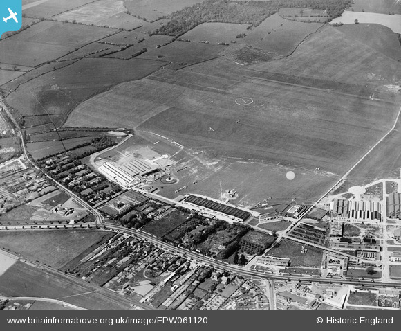
EPW061120 ENGLAND (1939). Hatfield Aerodrome, Hatfield, 1939
© Copyright OpenStreetMap contributors and licensed by the OpenStreetMap Foundation. 2026. Cartography is licensed as CC BY-SA.
Nearby Images (9)
Details
| Title | [EPW061120] Hatfield Aerodrome, Hatfield, 1939 |
| Reference | EPW061120 |
| Date | 30-May-1939 |
| Link | |
| Place name | HATFIELD |
| Parish | HATFIELD |
| District | |
| Country | ENGLAND |
| Easting / Northing | 521190, 208661 |
| Longitude / Latitude | -0.24370642880406, 51.763046108275 |
| National Grid Reference | TL212087 |
Pins

ken |
Wednesday 12th of August 2015 02:24:42 PM | |

ken |
Wednesday 12th of August 2015 02:23:33 PM | |

brian |
Wednesday 25th of February 2015 12:48:38 AM |


![[EPW061120] Hatfield Aerodrome, Hatfield, 1939](http://britainfromabove.org.uk/sites/all/libraries/aerofilms-images/public/100x100/EPW/061/EPW061120.jpg)
![[EPW042830] Hatfield Aerodrome, Hatfield, 1933](http://britainfromabove.org.uk/sites/all/libraries/aerofilms-images/public/100x100/EPW/042/EPW042830.jpg)
![[EPW042829] Hatfield Aerodrome Club House and hangars, Hatfield, 1933](http://britainfromabove.org.uk/sites/all/libraries/aerofilms-images/public/100x100/EPW/042/EPW042829.jpg)
![[EPW042828] Hatfield Aerodrome Club House and hangars, Hatfield, 1933](http://britainfromabove.org.uk/sites/all/libraries/aerofilms-images/public/100x100/EPW/042/EPW042828.jpg)
![[EPW061123] Birchwood, Roe Green, Hatfield Aerodrome and environs, Hatfield, 1939](http://britainfromabove.org.uk/sites/all/libraries/aerofilms-images/public/100x100/EPW/061/EPW061123.jpg)
![[EPW042825] Hatfield Aerodrome Club House and hangars, Hatfield, 1933](http://britainfromabove.org.uk/sites/all/libraries/aerofilms-images/public/100x100/EPW/042/EPW042825.jpg)
![[EPW042827] Hatfield Aerodrome Club House, Swimming Pool and hangars, Hatfield, 1933](http://britainfromabove.org.uk/sites/all/libraries/aerofilms-images/public/100x100/EPW/042/EPW042827.jpg)
![[EPW046577] Hatfield Aerodrome, Hatfield, 1935](http://britainfromabove.org.uk/sites/all/libraries/aerofilms-images/public/100x100/EPW/046/EPW046577.jpg)
![[EPW042826] Hatfield Aerodrome Swimming Pool, Hatfield, 1933](http://britainfromabove.org.uk/sites/all/libraries/aerofilms-images/public/100x100/EPW/042/EPW042826.jpg)